4. Polizeirevier (Bahnhofsgebiet)
4. Polizeirevier (Bahnhofsgebiet) is a police station in Frankfurt, South Hesse, Hesse which is located on Gutleutstraße. 4. Polizeirevier (Bahnhofsgebiet) is situated nearby to the courthouse Sozialgericht Frankfurt am Main, as well as near the church Gutleutkirche.| Tap on a place to explore it |
Places of Interest Nearby
Highlights include Frankfurt Hauptbahnhof and Gutleutkirche.
Frankfurt Hauptbahnhof
Railway station
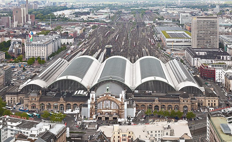
Photo: Der Wolf im Wald, CC BY-SA 3.0 de.
Frankfurt Hauptbahnhof, also called Frankfurt Central Station and Frankfurt Main Station, is the busiest train station in the German state of Hesse. Due to its location near the middle of Germany and usage as a transport hub for long and short distance travelling, Deutsche Bahn refers to it as the most important station in Germany. Frankfurt Hauptbahnhof is situated 360 metres north of 4. Polizeirevier (Bahnhofsgebiet).

Long-distance bus terminal
Bus station

Photo: Simsalabimbam, CC BY-SA 4.0.
Long-distance bus terminal is a bus station, which is situated 140 metres northeast of 4. Polizeirevier (Bahnhofsgebiet).
Places in the Area
Nearby places include Bahnhofsviertel and Westend.
Bahnhofsviertel
Suburb

Photo: Luisfff2812, CC BY 4.0.
The Bahnhofsviertel is a quarter of Frankfurt am Main, Germany. It is part of the Ortsbezirk Innenstadt I. The Bahnhofsviertel was developed between 1891 and 1915.
Westend
Suburb

Photo: Wikimedia, CC BY-SA 3.0.
Westend-Nord and Westend-Süd are two city districts of Frankfurt am Main, Germany. The division into a northern and a southern part is mostly for administrative purposes as the Westend is generally considered an entity.
Sachsenhausen
Suburb
Sachsenhausen-Nord and Sachsenhausen-Süd are two quarters of Frankfurt am Main, Germany. The division into a northern and a southern part is mostly for administrative purposes as Sachsenhausen is generally considered a single entity.
4. Polizeirevier (Bahnhofsgebiet)
- Type: Police station
- Address: Gutleutstraße 112, Frankfurt am Main, 60327
- Location: Frankfurt, South Hesse, Hesse, Germany, Central Europe, Europe
- View on OpenStreetMap
Latitude
50.10346° or 50° 6′ 13″ northLongitude
8.66191° or 8° 39′ 43″ eastOpen location code
9F2C4M36+9QOpenStreetMap ID
node 401296942OpenStreetMap feature
amenity=police
This page is based on OpenStreetMap, Wikidata, and Wikimedia Commons.
We’d love your help improving our open data sources. Thank you for contributing.
Satellite Map
Discover 4. Polizeirevier (Bahnhofsgebiet) from above in high-definition satellite imagery.
Notable Places Nearby
Highlights include Sozialgericht Frankfurt am Main and Arbeitsgericht Frankfurt am Main.
Nearby Places
Explore places such as ZYRES digital media systems GmbH and Hotel Minerva.
South Hesse: Must-Visit Destinations
Delve into Darmstadt, Bensheim, Lorsch, and Heppenheim.
Curious Police Stations to Discover
Uncover intriguing police stations from every corner of the globe.
About Mapcarta. Data © OpenStreetMap contributors and available under the Open Database License". Text is available under the CC BY-SA 4.0 license, except for photos, directions, and the map. Photo: Mylius, GFDL.