Dinvwiddie County Health Clinic
Dinvwiddie County Health Clinic is a clinic in Dinwiddie, Virginia. Dinvwiddie County Health Clinic is situated nearby to the government office Dinwiddie County Administration Building, as well as near the fire station Dinwiddie County Division of Fire / Emergency Medical Services.| Tap on a place to explore it |
Places of Interest Nearby
Highlights include Dinwiddie County Court House and Dinwiddie High School.
Dinwiddie County Court House
Courthouse

Photo: Cecouchman, CC BY-SA 3.0.
Dinwiddie County Court House is a historic courthouse building located at the junction of U.S. 1 and VA 619 in Dinwiddie, Dinwiddie County, Virginia. It was built in 1851, and is a two-story, brick temple-form building in the Greek Revival style. Dinwiddie County Court House is situated 640 feet northwest of Dinvwiddie County Health Clinic.
Dinwiddie High School
School building

Photo: Mojo Hand, CC BY-SA 4.0.
Dinwiddie High School is a secondary school in Dinwiddie County, Virginia, United States. It is the only high school in the county. Dinwiddie High School is situated 2½ miles north of Dinvwiddie County Health Clinic.
Places in the Area
Nearby places include Dinwiddie and Butterworth.
Dinwiddie
Village
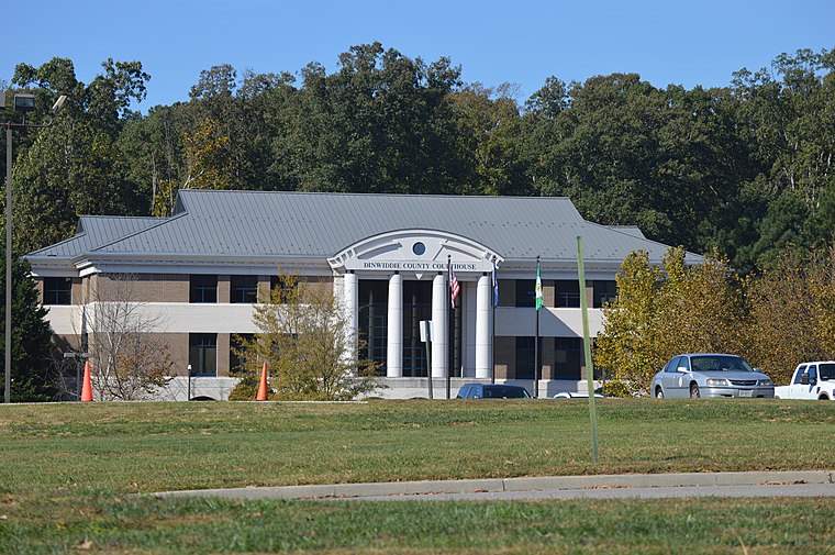
Photo: Nyttend, Public domain.
Dinwiddie is an unincorporated community, census-designated place, and the county seat of Dinwiddie County, Virginia, United States. It was first listed as a CDP in the 2020 census with a population of 619.
Butterworth
Hamlet
Butterworth is an unincorporated community in Dinwiddie County, Virginia, United States. Butterworth is located along a former railroad mainline. The Richmond, Petersburg and Carolina Railroad, passing through Butterworth from Petersburg to Ridgeway Junction, was completed in 1900, at which point it was merged into the Seaboard Air Line. Butterworth is situated 3 miles southwest of Dinvwiddie County Health Clinic.
DeWitt
Hamlet
DeWitt is an unincorporated community in Dinwiddie County, Virginia, United States. DeWitt is located on U.S. Route 1, 6 miles northeast of McKenney. It developed in a rural area of the county devoted to plantations worked by enslaved African Americans. DeWitt is situated 4 miles southwest of Dinvwiddie County Health Clinic.
Dinvwiddie County Health Clinic
- Type: Clinic
- Category: health care
- Location: Dinwiddie, Virginia, South, United States, North America
- View on OpenStreetMap
Latitude
37.0792° or 37° 4′ 45″ northLongitude
-77.58588° or 77° 35′ 9″ westOpen location code
87943CH7+MJOpenStreetMap ID
node 4042802686OpenStreetMap feature
amenity=clinic
This page is based on OpenStreetMap, Wikidata, and Wikimedia Commons.
We’d love your help improving our open data sources. Thank you for contributing.
Satellite Map
Discover Dinvwiddie County Health Clinic from above in high-definition satellite imagery.
Notable Places Nearby
Highlights include Dinwiddie County Administration Building and Dinwiddie County Division of Fire / Emergency Medical Services.
Nearby Places
Explore places such as Exxon and Food Barn.
Virginia: Must-Visit Destinations
Delve into Richmond, Arlington, Virginia Beach, and Norfolk.
Curious Clinics to Discover
Uncover intriguing clinics from every corner of the globe.
About Mapcarta. Data © OpenStreetMap contributors and available under the Open Database License". Text is available under the CC BY-SA 4.0 license, except for photos, directions, and the map. Photo: Wikimedia, CC0.