Angelina’s
Angelina’s is a scenic viewpoint in Staten Island, New York which is located on Ellis Street. Angelina’s is situated nearby to the metro station Tottenville station, as well as near the police station New York City Police Department - 123rd Precinct.| Tap on a place to explore it |
- Type: Scenic viewpoint
- Cuisine: Italian
- Address: 399 Ellis Street, Staten Island, 10312
- Wheelchair access: no
Places of Interest Nearby
Highlights include Tottenville station and Conference House.
Tottenville station
Metro station

Photo: Jim.henderson, Public domain.
The Tottenville station is a Staten Island Railway rapid transit station in the neighborhood of Tottenville, Staten Island, New York City. Located near Main Street and Arthur Kill Road, it is the southern terminus on the main line and the southernmost railway station in both New York City and New York State.
Conference House
Museum

Photo: Dmadeo, CC BY-SA 3.0.
Conference House is a stone house in the Tottenville neighborhood of Staten Island in New York City. Built by Captain Christopher Billopp some time before 1680, it is located in Conference House Park near Ward's Point, the southernmost tip of New York state, which became known as "Billop's Point" in the 18th century. Conference House is situated 3,800 feet south of Angelina’s.
Perth Amboy Ferry Slip
Museum
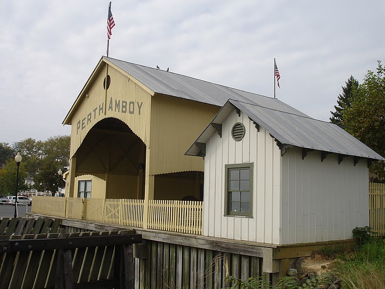
Photo: KForce, CC BY-SA 3.0.
The Perth Amboy Ferry Slip, located on the Arthur Kill in Perth Amboy, Middlesex County, New Jersey, United States, was once a vital ferry slip for boats in New York Harbor. Perth Amboy Ferry Slip is situated 3,800 feet southwest of Angelina’s.
Places in the Area
Nearby places include Tottenville and Harbortown, Perth Amboy.
Tottenville
Neighborhood
Tottenville is a neighborhood on the South Shore of Staten Island, New York City. It is the southernmost neighborhood and settlement in both New York City and New York State, as well as the westernmost neighborhood in New York City.
Harbortown, Perth Amboy
Hamlet

Photo: Jim.henderson, Public domain.
Harbortown is a planned community neighborhood in Perth Amboy in Middlesex County, in the U.S. state of New Jersey. It is situated south of the Outerbridge Crossing along the Arthur Kill, between the city's traditional waterfront and the Kinder Morgan…
Perth Amboy

Photo: Rafaelgarcia, CC BY-SA 3.0.
Perth Amboy is a city in northeastern Middlesex County, in the U.S. state of New Jersey, within the New York metropolitan area. As of the 2020 United States census, the city's population was 55,436.
Angelina’s
- Categories: restaurant and tourism
- Location: Staten Island, New York, Mid-Atlantic, United States, North America
- View on OpenStreetMap
Latitude
40.5134° or 40° 30′ 48″ northLongitude
-74.25136° or 74° 15′ 5″ westOpen location code
87G7GP7X+9FOpenStreetMap ID
node 411504676OpenStreetMap feature
amenity=restaurantOpenStreetMap feature
tourism=viewpointOpenStreetMap attribute
cuisine=italianOpenStreetMap attribute
wheelchair=no
This page is based on OpenStreetMap, Wikidata, and Wikimedia Commons.
We’d love your help improving our open data sources. Thank you for contributing.
Satellite Map
Discover Angelina’s from above in high-definition satellite imagery.
Notable Places Nearby
Highlights include New York City Police Department - 123rd Precinct and DeMarco’s Boxing Studio.
Nearby Places
Explore places such as Tottenville and Arthur Kill Road & Main Street.
New York: Must-Visit Destinations
Delve into New York City, Buffalo, Manhattan, and West Side.
Curious Scenic Viewpoints to Discover
Uncover intriguing scenic viewpoints from every corner of the globe.
About Mapcarta. Data © OpenStreetMap contributors and available under the Open Database License". Text is available under the CC BY-SA 4.0 license, except for photos, directions, and the map. Photo: Jjtkk, Public domain.