Fuerte Militar Alfredo Vargas Guerra
Fuerte Militar Alfredo Vargas Guerra is a barracks in Belén District, Maynas Province, Loreto. Fuerte Militar Alfredo Vargas Guerra is situated nearby to the military installation Soldado Vargas Guerra, as well as near the college UNAP - OGA.| Tap on a place to explore it |
Places of Interest Nearby
Highlights include Casa de Fierro and Estadio Max Augustín.
Casa de Fierro
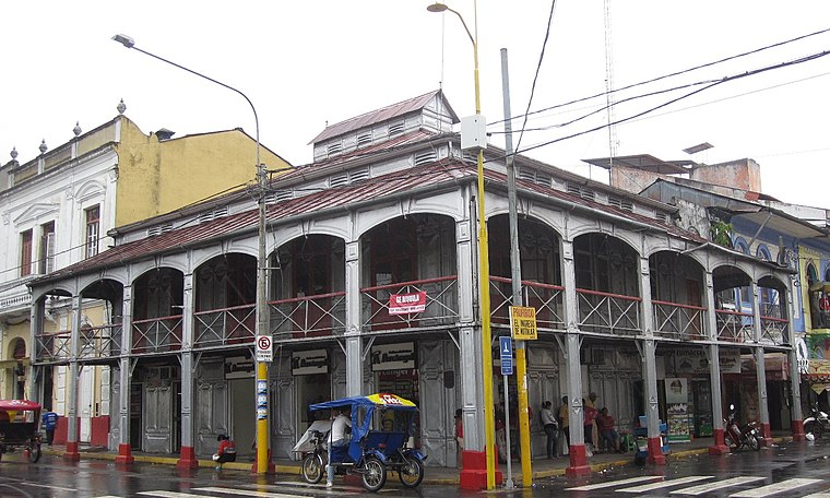
Photo: DiverDave, CC BY-SA 3.0.
La Casa de Fierro, located in the city of Iquitos in the jungle of Peru, in front of the major square between Próspero and Putumayo streets, is a large iron residence built during the rubber boom at the end of the nineteenth century. Casa de Fierro is situated 2 km northeast of Fuerte Militar Alfredo Vargas Guerra.
Estadio Max Augustín
Stadium

Photo: Andre 1102, CC BY-SA 4.0.
The Estadio Max Augustín is a multi-purpose stadium in Iquitos, Peru. It is the home ground of the football team AD Comerciantes FC, of the Peruvian Segunda División along with Colegio Nacional Iquitos and several other Copa Perú teams from Iquitos and the surrounding region. Estadio Max Augustín is situated 2 km northeast of Fuerte Militar Alfredo Vargas Guerra.
Plaza 28 de Julio
Park

Photo: Percy Meza, CC BY-SA 3.0.
Plaza 28 de Julio is a park, which is situated 1½ km northeast of Fuerte Militar Alfredo Vargas Guerra.
Places in the Area
Nearby places include Iquitos and Punchana.
Iquitos
 Iquitos is a city of 380,000 people in the Amazonas region of Peru. For travellers, Iquitos offers a vast selection of activities not found elsewhere in Peru, such as Amazon boat rides and great wildlife viewing.
Punchana
Suburb
Punchana is the capital of the Punchana District in the Maynas Province of the Loreto Region in northeastern Peru, in the Peruvian Amazon Jungle. It is a neighborhood on the outskirts of the city of Iquitos, located on the Amazon and the Nanay Rivers. Punchana is situated 4 km northeast of Fuerte Militar Alfredo Vargas Guerra.
Fuerte Militar Alfredo Vargas Guerra
- Type: Barracks
- Categories: military installation, residential building, and building
- Location: Belén District, Maynas Province, Loreto, Peru, South America
- View on OpenStreetMap
Latitude
-3.76036° or 3° 45′ 37″ southLongitude
-73.26129° or 73° 15′ 41″ westOpen location code
67886PQQ+VFOpenStreetMap ID
node 412510393OpenStreetMap feature
military=barracks
This page is based on OpenStreetMap, Wikidata, and Wikimedia Commons.
We’d love your help improving our open data sources. Thank you for contributing.
Satellite Map
Discover Fuerte Militar Alfredo Vargas Guerra from above in high-definition satellite imagery.
Notable Places Nearby
Highlights include Soldado Vargas Guerra and Comisaría PNP 9 de Octubre.
Nearby Places
Explore places such as Institución Educativa 601555 Tarapaca and Institución educativa inicial 328 Tarapaca.
Peru: Must-Visit Destinations
Delve into Lima, Machu Picchu, Cuzco, and Arequipa.
Curious Barracks to Discover
Uncover intriguing barracks from every corner of the globe.
About Mapcarta. Data © OpenStreetMap contributors and available under the Open Database License". Text is available under the CC BY-SA 4.0 license, except for photos, directions, and the map. Photo: Wikimedia, CC BY 3.0.