Jardin de la Garenne
Jardin de la Garenne is a park in Villeneuve-lès-Avignon, Arrondissement of Nîmes, Occitanie. Jardin de la Garenne is situated nearby to the park Jardin sec, as well as near Salle de danse.| Tap on a place to explore it |
Places of Interest Nearby
Highlights include Charterhouse Notre-Dame du Val de Bénédiction and Fort Saint-André.
Charterhouse Notre-Dame du Val de Bénédiction
Museum

Photo: Baldiri, CC BY-SA 3.0.
Charterhouse Notre-Dame du Val de Bénédiction is a museum, which is situated 1½ km southeast of Jardin de la Garenne.
Fort Saint-André

Photo: Wikimedia, CC BY-SA 3.0.
The Fort Saint-André is a medieval fortress in the commune of Villeneuve-lès-Avignon in the Gard département of France, dating from the first half of the 14th century. Fort Saint-André is situated 2 km southeast of Jardin de la Garenne.
Pierre de Luxembourg museum
Museum

Photo: Enguerrand Quarton, Public domain.
Pierre de Luxembourg museum is situated 2 km southeast of Jardin de la Garenne.
Places in the Area
Nearby places include Villeneuve-lès-Avignon and Ile Piot.
Villeneuve-lès-Avignon
Town
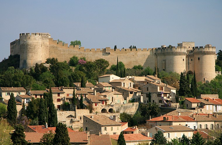
Photo: Luu, CC BY-SA 3.0.
Villeneuve-lès-Avignon is a commune in the Gard department in southern France. It can also be spelled Villeneuve-lez-Avignon.
Ile Piot
Locality

Photo: Txllxt TxllxT, CC BY-SA 4.0.
Ile Piot is a locality, which is situated 3 km south of Jardin de la Garenne.
Pujaut
Village

Photo: Inkey, CC BY-SA 3.0.
Pujaut is a commune in the Gard department in southern France. The village is situated on the south side of a small hill overlooking a flat plain that once formed the bed of a lake. Pujaut is situated 3½ km north of Jardin de la Garenne.
Jardin de la Garenne
- Type: Park
- Category: recreation area
- Location: Villeneuve-lès-Avignon, Arrondissement of Nîmes, Gard, Occitanie, France, Europe
- View on OpenStreetMap
Latitude
43.97401° or 43° 58′ 26″ northLongitude
4.7794° or 4° 46′ 46″ eastOpen location code
8FM6XQFH+JQOpenStreetMap ID
node 4157768402OpenStreetMap feature
leisure=park
This page is based on OpenStreetMap, Wikidata, and Wikimedia Commons.
We’d love your help improving our open data sources. Thank you for contributing.
Satellite Map
Discover Jardin de la Garenne from above in high-definition satellite imagery.
Places with the Same Name
Discover other places named “Jardin de la Garenne”.
Notable Places Nearby
Highlights include Jardin sec and Salle de danse.
Nearby Places
Explore places such as Cévennes and Mont Serein.
Gard: Must-Visit Destinations
Delve into Nîmes, Alès, Aigues-Mortes, and Remoulins.
Curious Parks to Discover
Uncover intriguing parks from every corner of the globe.
About Mapcarta. Data © OpenStreetMap contributors and available under the Open Database License". Text is available under the CC BY-SA 4.0 license, except for photos, directions, and the map. Photo: NikosB30, CC BY-SA 3.0.