Textilpflege - Wohlfahrt
Textilpflege - Wohlfahrt is a dry cleaner in Kulmbach, Upper Franconia, Bavaria. Textilpflege - Wohlfahrt is situated nearby to the post office maintabac, as well as near the church Jesus-Live-Gemeinde.| Tap on a place to explore it |
Places of Interest Nearby
Highlights include Kulmbach and Station building at Kulmbach station.
Kulmbach
Railway station

Photo: Wikimedia, Public domain.
Kulmbach station is a railway station in the municipality of Kulmbach, located in the district of Kulmbach in Middle Franconia, Germany. Kulmbach is situated 290 metres south of Textilpflege - Wohlfahrt.
Station building at Kulmbach station
Railway station
Photo: Wikimedia, Public domain.
Station building at Kulmbach station is a railway station, which is situated 310 metres south of Textilpflege - Wohlfahrt.
Plassenburg
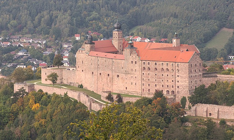
Photo: El Grafo, CC BY-SA 4.0.
Plassenburg is a castle in the city of Kulmbach in Bavaria. It is one of the most impressive castles in Germany and a symbol of the city. It was first mentioned in 1135. Plassenburg is situated 1 km southeast of Textilpflege - Wohlfahrt.
Places in the Area
Nearby places include Ziegelhütten (Kulmbach) and Petzmannsberg.


Mangersreuth
Village
 Mangersreuth is a village, which is situated 2½ km south of Textilpflege - Wohlfahrt.
Textilpflege - Wohlfahrt
- Opening hours:
Monday, Tuesday, Thursday, and Friday: 7:30 AM—6:00 PM
Wednesday: 7:30 AM—3:00 PM
Saturday: 9:00 AM—1:00 PM - Type: Dry cleaner
- Category: shop
- Location: Kulmbach, Kulmbach, Upper Franconia, Franconia, Bavaria, Germany, Central Europe, Europe
- View on OpenStreetMap
Latitude
50.11239° or 50° 6′ 45″ northLongitude
11.45257° or 11° 27′ 9″ eastOpen location code
9F2H4F63+X2OpenStreetMap ID
node 4217870691OpenStreetMap feature
shop=dry_cleaning
This page is based on OpenStreetMap, Wikidata, and Wikimedia Commons.
We’d love your help improving our open data sources. Thank you for contributing.
Satellite Map
Discover Textilpflege - Wohlfahrt from above in high-definition satellite imagery.
Notable Places Nearby
Highlights include maintabac and Jesus-Live-Gemeinde.
Nearby Places
Explore places such as SB Waschboxen WAP and Waschstraße WAP.
Upper Franconia: Must-Visit Destinations
Delve into Bamberg, Bayreuth, Coburg, and Hof.
Curious Dry Cleaners to Discover
Uncover intriguing dry cleaners from every corner of the globe.
About Mapcarta. Data © OpenStreetMap contributors and available under the Open Database License". Text is available under the CC BY-SA 4.0 license, except for photos, directions, and the map. Photo: Wikimedia, CC0.