la forestal
la forestal is a bus stop in Quito, Pichincha. la forestal is situated nearby to the place of worship Iglesia Evangélica Apostólica del Nombre de Jesús - El Pedestal, as well as near the pitch Liga Barrial San Patricio.| Tap on a place to explore it |
Places of Interest Nearby
Highlights include Palacio de Carondelet and El Panecillo.
Palacio de Carondelet
Government office
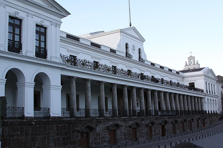 Carondelet Palace is the seat of government of the Republic of Ecuador, located in Quito. Access is by the public space known as Independence Square or Plaza Grande, around which are also the Archbishop's Palace, Municipal Palace, Hotel Plaza Grande, and Metropolitan Cathedral. Palacio de Carondelet is situated 4 km north of la forestal.
El Panecillo
Peak

Photo: Cayambe, CC BY-SA 3.0.
El Panecillo is a 200-metre-high hill of volcanic-origin, with loess soil, located between southern and central Quito. Its peak is at an elevation of 3,016 metres above sea level. El Panecillo is situated 3½ km northwest of la forestal.
City of Quito
Protected area

Photo: Hubertl, CC BY-SA 4.0.
City of Quito is a protected area, which is situated 4 km north of la forestal.
Places in the Area
Nearby places include Quito.
Quito
 Quito, the capital of Ecuador, was founded in 1534 on the ruins of an ancient Inca city. Quito's Old City is the largest in the Americas and was one of the first UNESCO World Heritage Sites, recognized as the largest and most intact colonial city center remaining in the Americas.
la forestal
- Type: Bus stop
- Categories: transport stop and transportation
- Location: Quito, Quito Canton, Pichincha, Ecuador, South America
- View on OpenStreetMap
Latitude
-0.2545° or 0° 15′ 16″ southLongitude
-78.50395° or 78° 30′ 14″ westOpen location code
67F3PFWW+6COpenStreetMap ID
node 4227109836OpenStreetMap feature
highway=bus_stopOpenStreetMap feature
public_transport=stop_position
This page is based on OpenStreetMap, Wikidata, and Wikimedia Commons.
We’d love your help improving our open data sources. Thank you for contributing.
Satellite Map
Discover la forestal from above in high-definition satellite imagery.
Places with the Same Name
Discover other places named “la forestal”.
Notable Places Nearby
Highlights include Unida de Policia Comunitaria La Forestal and Iglesia Evangélica Apostólica del Nombre de Jesús - El Pedestal.
Nearby Places
Explore places such as forestal and Gusñay Padilla Juan Cornelio.
Ecuador: Must-Visit Destinations
Delve into Quito, Guayaquil, Chimborazo, and Cuenca.
Curious Bus Stops to Discover
Uncover intriguing bus stops from every corner of the globe.
About Mapcarta. Data © OpenStreetMap contributors and available under the Open Database License". Text is available under the CC BY-SA 4.0 license, except for photos, directions, and the map. Photo: Wikimedia, CC0.