Prandaugasse
Prandaugasse is a tram stop in Donaustadt, Vienna. Prandaugasse is situated nearby to the social service facility Haus der Barmherzigkeit, as well as near Japanese International School in Vienna.| Tap on a place to explore it |
Places of Interest Nearby
Highlights include Japanese International School in Vienna and Vienna International School.
Japanese International School in Vienna
School
 The Japanese International School in Vienna is a Japanese international school in Donaustadt, Vienna, Austria. The school was established in 1978. Japanese International School in Vienna is situated 110 metres southwest of Prandaugasse.
Vienna International School
School
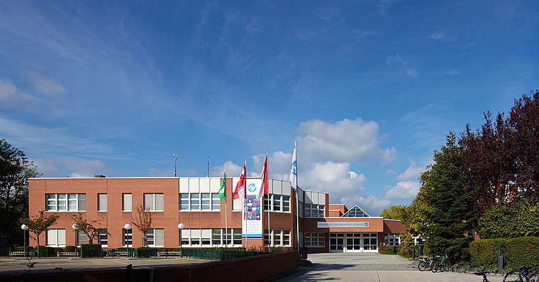
Photo: Quovadit, CC BY-SA 4.0.
Vienna International School is a non-profit international school in Vienna, Austria. The school was built to accommodate the children of United Nations employees and diplomats when the UN decided to locate one of its offices in Vienna, and it remains affiliated to the UN. Vienna International School is situated 200 metres south of Prandaugasse.
Österreichisches Gartenbaumuseum
Museum

Photo: Quovadit, CC BY-SA 4.0.
Österreichisches Gartenbaumuseum is situated 360 metres south of Prandaugasse.
Places in the Area
Nearby places include Outer East and Bruckhaufen.
Outer East

Photo: D.W., Public domain.
Outer East describes the Vienna districts Floridsdorf and Donaustadt.

Großfeldsiedlung
Neighborhood

Photo: Thomas Ledl, CC BY-SA 4.0.
Großfeldsiedlung is a neighborhood, which is situated 3 km northeast of Prandaugasse.
Prandaugasse
- Type: Tram stop
- Wheelchair access: yes
- Categories: railway stop, transport stop, and transportation
- Location: Donaustadt, Vienna, Austria, Central Europe, Europe
- View on OpenStreetMap
Latitude
48.24688° or 48° 14′ 49″ northLongitude
16.43008° or 16° 25′ 48″ eastOperator
Wiener LinienNetwork
Verkehrsverbund Ost-RegionOpen location code
8FWR6CWJ+Q2OpenStreetMap ID
node 4246679917OpenStreetMap feature
public_transport=stop_positionOpenStreetMap feature
railway=tram_stopOpenStreetMap attribute
wheelchair=yes
This page is based on OpenStreetMap, Wikidata, and Wikimedia Commons.
We’d love your help improving our open data sources. Thank you for contributing.
Satellite Map
Discover Prandaugasse from above in high-definition satellite imagery.
Notable Places Nearby
Highlights include Wien Prandaugasse and Haus der Barmherzigkeit.
Nearby Places
Explore places such as Kindercompany and Volksschule Prandaugasse.
Vienna: Must-Visit Destinations
Delve into Innere Stadt, Vienna International Airport, Inner East, and Hietzing.
Curious Tram Stops to Discover
Uncover intriguing tram stops from every corner of the globe.
About Mapcarta. Data © OpenStreetMap contributors and available under the Open Database License". Text is available under the CC BY-SA 4.0 license, except for photos, directions, and the map. Photo: Jebulon, CC0.