Lac de Guerledan - Point de vue du Rond-point du lac
Lac de Guerledan - Point de vue du Rond-point du lac is a scenic viewpoint in Côtes-d’Armor, Brittany. Lac de Guerledan - Point de vue du Rond-point du lac is situated nearby to the tourism office Office du Tourisme du Lac de Guerlédan, as well as near Base départementale de plein air Lac de Guerlédan.| Tap on a place to explore it |
Places of Interest Nearby
Highlights include Castel-Finans and Chapelle Sainte-Tréphine de Saint-Aignan.
Castel-Finans
Archaeological site

Photo: Pymouss, CC BY-SA 3.0.
Castel-Finans is an archaeological site, which is situated 1 km southwest of Lac de Guerledan - Point de vue du Rond-point du lac.
Chapelle Sainte-Tréphine de Saint-Aignan
Church

Photo: Amanda.Hinault, CC BY-SA 4.0.
Chapelle Sainte-Tréphine de Saint-Aignan is a church, which is situated 1 km southwest of Lac de Guerledan - Point de vue du Rond-point du lac.
Barrage de Guerlédan
Dam
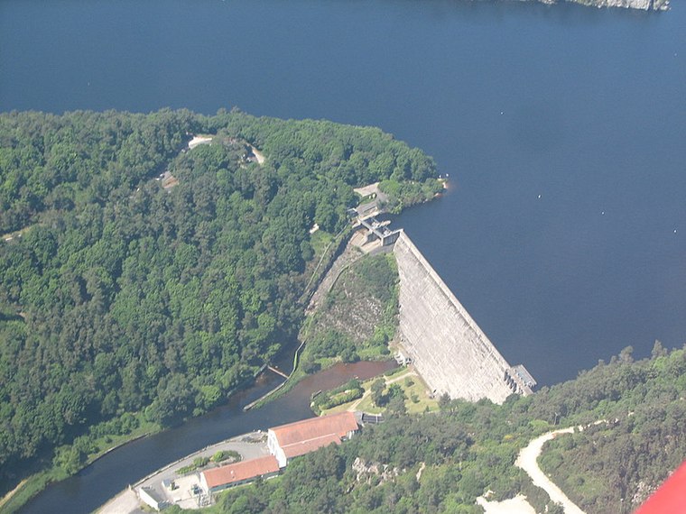
Photo: Pilot‘22, CC BY-SA 2.5.
Barrage de Guerlédan is a dam, which is situated 530 metres southwest of Lac de Guerledan - Point de vue du Rond-point du lac.
Places in the Area
Nearby places include Saint-Aignan.
Saint-Aignan
Village

Photo: GO69, CC BY-SA 3.0.
Saint-Aignan is a commune in the Morbihan department of Brittany in north-western France. Inhabitants of Saint-Aignan are called in French Saintaignanais.
Lac de Guerledan - Point de vue du Rond-point du lac
- Type: Scenic viewpoint
- Category: tourism
- Location: Côtes-d’Armor, Brittany, France, Europe
- View on OpenStreetMap
Latitude
48.19826° or 48° 11′ 54″ northLongitude
-3.01308° or 3° 0′ 47″ westOpen location code
8CWR5XXP+8QOpenStreetMap ID
node 4260198301OpenStreetMap feature
tourism=viewpoint
This page is based on OpenStreetMap, Wikidata, and Wikimedia Commons.
We’d love your help improving our open data sources. Thank you for contributing.
Satellite Map
Discover Lac de Guerledan - Point de vue du Rond-point du lac from above in high-definition satellite imagery.
Notable Places Nearby
Highlights include Base départementale de plein air Lac de Guerlédan and Office du Tourisme du Lac de Guerlédan.
Nearby Places
Explore places such as Pays de Guerlédan-Argoat and Station VTT Guerlédan.
Brittany: Must-Visit Destinations
Delve into Rennes, Brest, Finistère, and Morbihan.
Curious Scenic Viewpoints to Discover
Uncover intriguing scenic viewpoints from every corner of the globe.
About Mapcarta. Data © OpenStreetMap contributors and available under the Open Database License". Text is available under the CC BY-SA 4.0 license, except for photos, directions, and the map. Photo: Spendeau, CC BY-SA 3.0.