Peperpot Nature Reserve Information Centre
Peperpot Nature Reserve Information Centre is a museum in Commewijne District, Suriname which is located on Oost west Verbinding Commewijne. Peperpot Nature Reserve Information Centre is situated nearby to Trails, as well as near the government office Ministry.| Tap on a place to explore it |
- Opening hours: Tuesday—Sunday 8:30 AM—5:00 PM
- Type: Museum
- Address: Oost west Verbinding Commewijne
Places in the Area
Nearby places include Meerzorg and Rainville.
Meerzorg
Village
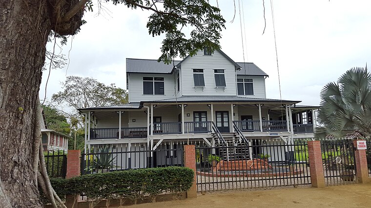
Photo: Humbert-L-Siegers, CC BY-SA 4.0.
Meerzorg is a town and resort in Suriname, located on the eastern bank of the Suriname River, directly opposite the capital Paramaribo. Its population at the 2012 census was 12,405. Meerzorg is situated 3 km west of Peperpot Nature Reserve Information Centre.
Rainville
Village
Rainville is a resort in Suriname, located in the Paramaribo District. Its population at the 2012 census was 22,747. The Rainville resort is home to the Paramaribo Zoo. Rainville is situated 4½ km northwest of Peperpot Nature Reserve Information Centre.
Noord
Town
Noord is a resort in Suriname, located in the Para District. Its population at the 2012 census was 9,703. Noord is mainly an agricultural area, and has a school. Noord is situated 6 km north of Peperpot Nature Reserve Information Centre.
Peperpot Nature Reserve Information Centre
- Categories: tourism and tourist attraction
- Location: Commewijne District, Suriname, South America
- View on OpenStreetMap
Latitude
5.80048° or 5° 48′ 2″ northLongitude
-55.11866° or 55° 7′ 7″ westOpen location code
68Q6RV2J+5GOpenStreetMap ID
node 4350177054OpenStreetMap feature
tourism=museum
This page is based on OpenStreetMap, Wikidata, and Wikimedia Commons.
We’d love your help improving our open data sources. Thank you for contributing.
Satellite Map
Discover Peperpot Nature Reserve Information Centre from above in high-definition satellite imagery.
Notable Places Nearby
Highlights include Trails and Ministry.
Nearby Places
Explore places such as Self Reliance and Simply Beautiful.
Suriname: Must-Visit Destinations
Delve into Paramaribo, Surinamese Rainforest, East Coast, and West Coast.
Curious Museums to Discover
Uncover intriguing museums from every corner of the globe.
About Mapcarta. Data © OpenStreetMap contributors and available under the Open Database License". Text is available under the CC BY-SA 4.0 license, except for photos, directions, and the map. Photo: S23678, CC BY-SA 3.0.