Seti Lab
Seti Lab is a clinic in Paramaribo District, Suriname. Seti Lab is situated nearby to Line 5 bus station, as well as near the bus station Heiligenweg.| Tap on a place to explore it |
Places of Interest Nearby
Highlights include Presidential Palace of Suriname and Martin Luther Church.
Presidential Palace of Suriname
Government office

Photo: Ian Mackenzie, CC BY 2.0.
The Presidential Palace of Suriname is the presidential palace of Suriname in the capital of Paramaribo. It is located across from The Independence Square, which also houses the National Assembly of Suriname, the Congress building, the Court of Justice, and the Ministry of Finance. Presidential Palace of Suriname is situated 700 metres northeast of Seti Lab.
Martin Luther Church
Church

Photo: Mark Ahsmann, CC BY-SA 3.0.
The Martin Luther Church is a church of the Evangelical Lutheran Church in Suriname. It is located on Waterkant in the historic centre of Paramaribo, Suriname. The building is a monument. The first church burnt down in 1832. The current church dates from 1834. Martin Luther Church is situated 280 metres west of Seti Lab.
Statue of Mahatma Ghandi, Paramaribo
Memorial

Photo: Otter, CC BY-SA 4.0.
Statue of Mahatma Ghandi, Paramaribo is a memorial, which is situated 160 metres north of Seti Lab.
Places in the Area
Nearby places include Paramaribo and Rainville.
Paramaribo

Photo: Sn.fernandez, CC BY-SA 4.0.
Paramaribo, often called Par'bo, is the lively capital and only city of the sparsely inhabited country of Suriname. Home to about 240,000 people, or over half of the country's population, this laid-back South American gem lies 15 km from the Atlantic Ocean.
Rainville
Village
Rainville is a resort in Suriname, located in the Paramaribo District. Its population at the 2012 census was 22,747. The Rainville resort is home to the Paramaribo Zoo.
Meerzorg
Village
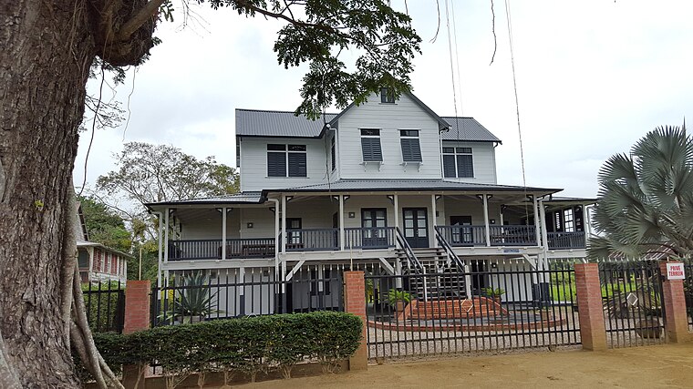
Photo: Humbert-L-Siegers, CC BY-SA 4.0.
Meerzorg is a town and resort in Suriname, located on the eastern bank of the Suriname River, directly opposite the capital Paramaribo. Its population at the 2012 census was 12,405.
Seti Lab
- Type: Clinic
- Category: health care
- Location: Paramaribo District, Suriname, South America
- View on OpenStreetMap
Latitude
5.82429° or 5° 49′ 27″ northLongitude
-55.15706° or 55° 9′ 25″ westOpen location code
68Q6RRFV+P5OpenStreetMap ID
node 4408361839OpenStreetMap feature
amenity=clinicOpenStreetMap feature
healthcare=clinic
This page is based on OpenStreetMap, Wikidata, and Wikimedia Commons.
We’d love your help improving our open data sources. Thank you for contributing.
Satellite Map
Discover Seti Lab from above in high-definition satellite imagery.
Notable Places Nearby
Highlights include Line 5 bus station and Heiligenweg.
Nearby Places
Explore places such as City Gold and KFC.
Suriname: Must-Visit Destinations
Delve into Paramaribo, Surinamese Rainforest, East Coast, and West Coast.
Curious Clinics to Discover
Uncover intriguing clinics from every corner of the globe.
About Mapcarta. Data © OpenStreetMap contributors and available under the Open Database License". Text is available under the CC BY-SA 4.0 license, except for photos, directions, and the map. Photo: S23678, CC BY-SA 3.0.