Centre de Planification et d’Education Familiale
Centre de Planification et d’Education Familiale is a clinic in Cayenne, Guyane which is located on Avenue François Ronjon. Centre de Planification et d’Education Familiale is situated nearby to the church Église Chrétienne Évangelique, as well as near the sports venue Complexe Sportif Arsène Saibou.| Tap on a place to explore it |
- Opening hours:
Monday: 7:35 AM—3:45 PM
Tuesday: 7:35 AM—2:15 PM
Wednesday: 7:35 AM—1:30 PM
Thursday: 7:35 AM—3:45 PM
Friday: 7:35 AM—1:30 PM - Type: Clinic
- Also known as: “CPEF”
- Address: 34 Avenue François Ronjon, Cayenne, 97300
Places of Interest Nearby
Highlights include Immeuble Vitalo and Cayenne Cathedral.
Immeuble Vitalo
Historic building
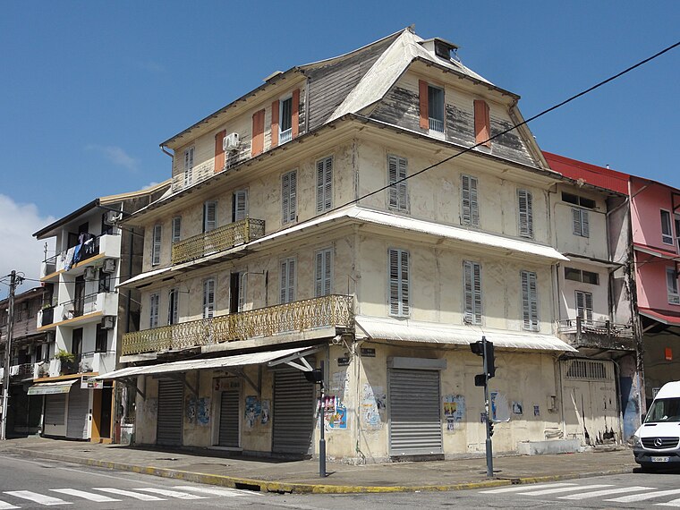
Photo: Aandrem, CC BY-SA 4.0.
Immeuble Vitalo is a historic building, which is situated 370 metres northwest of Centre de Planification et d’Education Familiale.
Cayenne Cathedral
Church

Photo: Wikimedia, CC BY-SA 3.0.
Cayenne Cathedral is a Roman Catholic cathedral, seat of the Diocese of Cayenne. It is a national monument of France, located in the town of Cayenne, capital of French Guiana. Cayenne Cathedral is situated 680 metres north of Centre de Planification et d’Education Familiale.
Maison-Musée de Félix Éboué
Museum

Photo: Lydav, CC BY-SA 3.0.
Maison-Musée de Félix Éboué is a museum, which is situated 560 metres north of Centre de Planification et d’Education Familiale.
Places in the Area
Nearby places include Remire-Montjoly and Matoury.
Remire-Montjoly
Town

Photo: Lebrouillard, CC BY-SA 3.0.
Remire-Montjoly is a commune of French Guiana, an overseas region and department of France located on the northeast coast of South America. Remire-Montjoly is a suburb of Cayenne, the capital préfecture and largest city of French Guiana. Remire-Montjoly is situated 7 km southeast of Centre de Planification et d’Education Familiale.
Matoury
Town

Photo: Bernard DUPONT, CC BY-SA 2.0.
Matoury is a commune of French Guiana, an overseas region and department of France located in South America. Matoury is a southern suburb of Cayenne, the préfecture and largest city of French Guiana. Cayenne – Félix Eboué Airport, the main international airport of French Guiana, is located in the commune of Matoury. Matoury is situated 9 km south of Centre de Planification et d’Education Familiale.
Centre de Planification et d’Education Familiale
- Category: health care
- Location: Cayenne, Arrondissement of Cayenne, Guyane, French Guiana, South America
- View on OpenStreetMap
Latitude
4.93401° or 4° 56′ 2″ northLongitude
-52.32966° or 52° 19′ 47″ westOperator
Collectivité Territoriale de GuyaneOpen location code
68P9WMMC+J4OpenStreetMap ID
node 4424354275OpenStreetMap feature
amenity=clinicOpenStreetMap feature
healthcare=clinic
This page is based on OpenStreetMap, Wikidata, and Wikimedia Commons.
We’d love your help improving our open data sources. Thank you for contributing.
Satellite Map
Discover Centre de Planification et d’Education Familiale from above in high-definition satellite imagery.
Notable Places Nearby
Highlights include Église Chrétienne Évangelique and Complexe Sportif Arsène Saibou.
Nearby Places
Explore places such as Centre de Protection Maternelle et Infantile Ronjon and 265 Ronjon.
French Guiana: Must-Visit Destinations
Delve into Cayenne, Kourou, Saint-Laurent-du-Maroni, and Saint-Georges.
Curious Clinics to Discover
Uncover intriguing clinics from every corner of the globe.
About Mapcarta. Data © OpenStreetMap contributors and available under the Open Database License". Text is available under the CC BY-SA 4.0 license, except for photos, directions, and the map. Photo: Wikimedia, CC0.