Vinárky
Vinárky is a quarter in Bratislava-Staré Mesto, Bratislava 1, Bratislava Region. Vinárky is situated nearby to the quarter Bôrik, as well as near the neighborhood Somársky vrch.| Tap on a place to explore it |
Places of Interest
Highlights include Embassy of Ukraine and Bratislava Castle.
Embassy of Ukraine
Government office
Slovenia–Ukraine relations are bilateral relations between Ukraine and Slovenia. Slovenia recognized Ukraine's independence on 11 December 1991, and diplomatic relations were established three months later, on 10 March 1992.
Bratislava Castle
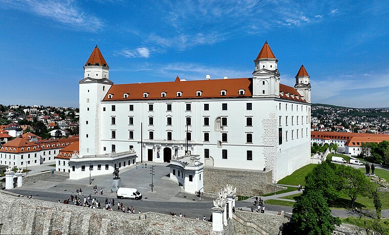
Photo: Bwag, CC BY-SA 4.0.
Bratislava Castle is the main castle of Bratislava, the capital of Slovakia. The massive rectangular building with four corner towers stands on an isolated rocky hill of the Little Carpathians, directly above the Danube river, in the middle of Bratislava.
Lanfranconi Bridge
Bridge

Photo: Cornischong, CC BY-SA 3.0.
Lanfranconi Bridge is a concrete motorway bridge in Bratislava, Slovakia, located on the D2 motorway. It was built in 1985–1991, with its right half opened in 1990 and the rest in 1992.
Places in the Area
Nearby places include Podhradie and Vydrica.
Podhradie
Neighborhood
Podhradie is a historical part of Bratislava, the capital of Slovakia, situated around the Bratislava Castle hill. Today, it consists of the areas of Zuckermandel, Vydrica and the area above Židovská Street.


Vinárky
- Type: Quarter
- Category: locality
- Location: Bratislava-Staré Mesto, Bratislava 1, Bratislava Region, Slovakia, Central Europe, Europe
- View on OpenStreetMap
Latitude
48.14584° or 48° 8′ 45″ northLongitude
17.083° or 17° 4′ 59″ eastOpen location code
8FWV43WM+85OpenStreetMap ID
node 4430151327OpenStreetMap feature
place=quarter
This page is based on OpenStreetMap, Wikidata, and Wikimedia Commons.
We’d love your help improving our open data sources. Thank you for contributing.
Satellite Map
Discover Vinárky from above in high-definition satellite imagery.
Localities in the Area
Explore places such as Bôrik and Somársky vrch.
Notable Places Nearby
Highlights include Židovský neologický cintorín and Machnáč.
Slovakia: Must-Visit Destinations
Delve into Bratislava, Košice, Banská Bystrica, and Trnava.
Curious Quarters to Discover
Uncover intriguing quarters from every corner of the globe.
About Mapcarta. Data © OpenStreetMap contributors and available under the Open Database License". Text is available under the CC BY-SA 4.0 license, except for photos, directions, and the map. Photo: Danapit, CC BY-SA 3.0.