Llama Votiva de la Argentinidad
Llama Votiva de la Argentinidad is a memorial in Entre Rios, Mesopotamia. Llama Votiva de la Argentinidad is situated nearby to the museum Galería de Honor de las Banderas de América, as well as near the park Plaza Imperia.| Tap on a place to explore it |
- Type: Memorial
- Also known as: “Urna cineraria al Soldado Desconocido”
- Inscription: “Aquí reposan los restos del soldado argentino muerto por la libertad de la Patria”
- Wheelchair access: limited
Places of Interest Nearby
Highlights include Municipal Council Rosario and Palacio de los Leones.
Municipal Council Rosario
Town hall

Photo: ElGuruCesar, CC BY-SA 4.0.
Palacio Vasallo is the seat of the Legislative Branch of the municipal government of Rosario, province of Santa Fe, Argentina. The building, designed by Alejo Infante and completed in 1911, is located near the National Flag Memorial, and has been the site of Rosario's Deliberative Council since May 18, 1951. Municipal Council Rosario is situated 110 metres southeast of Llama Votiva de la Argentinidad.
Palacio de los Leones
Town hall
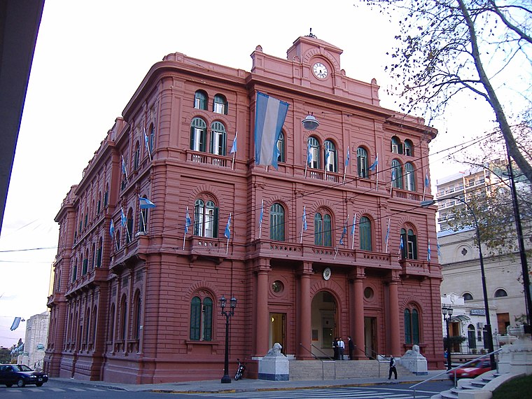
Photo: Pablo-flores, CC BY-SA 2.5.
Palacio de los Leones is the name of the main municipal building of the city of Rosario, Argentina. The Palace is the seat of the executive branch of the municipal government. Palacio de los Leones is situated 130 metres northwest of Llama Votiva de la Argentinidad.
Cathedral Basilica of Our Lady of the Rosary
Church

Photo: Fulviusbsas, CC BY-SA 3.0.
The Cathedral Basilica Shrine of Our Lady of the Rosary is a minor basilica and cathedral dedicated to the local Virgin of the Rosary, in the city of Rosario, province of Santa Fe, Argentina. Cathedral Basilica of Our Lady of the Rosary is situated 130 metres west of Llama Votiva de la Argentinidad.
Places in the Area
Nearby places include Barrio Pichincha and Rosario.
Barrio Pichincha
Suburb
Pichincha is a barrio in the city of Rosario, province of Santa Fe, Argentina. It is located on the north-east part of the central area of the city, and its limits are Vera Mujica St, Cordoba St, Oroño Boulevard, and Del Valle Avenue. Barrio Pichincha is situated 3 km west of Llama Votiva de la Argentinidad.
Rosario

Photo: ElGuruCesar, CC BY-SA 4.0.
Rosario is the third largest city in Argentina and the largest city in Santa Fe province, at the Paraná river. It is known for its rich architectural heritage and beautiful riverside scenery, and offers a vibrant cultural and night life.
Barrio Echesortu
Suburb
Echesortu is a barrio in Rosario, Argentina. It is unofficially known by that name even though, from the administrative point of view, its name is Remedios Escalada de San Martín. Barrio Echesortu is situated 5 km west of Llama Votiva de la Argentinidad.
Llama Votiva de la Argentinidad
- Category: historic site
- Location: Entre Rios, Mesopotamia, Argentina, South America
- View on OpenStreetMap
Latitude
-32.94759° or 32° 56′ 51″ southLongitude
-60.63092° or 60° 37′ 51″ westInception
June 20th, 1957Open location code
47VX3929+XJOpenStreetMap ID
node 4542174554OpenStreetMap feature
historic=memorialOpenStreetMap attribute
wheelchair=limited
This page is based on OpenStreetMap, Wikidata, and Wikimedia Commons.
We’d love your help improving our open data sources. Thank you for contributing.
Satellite Map
Discover Llama Votiva de la Argentinidad from above in high-definition satellite imagery.
Notable Places Nearby
Highlights include Galería de Honor de las Banderas de América and Plaza Imperia.
Nearby Places
Explore places such as América Indígena and América Constitucional.
Entre Rios: Must-Visit Destinations
Delve into Paraná, Concordia, Gualeguaychu, and El Palmar National Park.
Curious Memorials to Discover
Uncover intriguing memorials from every corner of the globe.
About Mapcarta. Data © OpenStreetMap contributors and available under the Open Database License". Text is available under the CC BY-SA 4.0 license, except for photos, directions, and the map. Photo: Wikimedia, CC0.