HeBi - Egregy
HeBi - Egregy is a bike rental in Veszprém County, Central Transdanubia. HeBi - Egregy is situated nearby to the church Jézus Szíve-templom, as well as near the archaeological site római villa.| Tap on a place to explore it |
Places of Interest Nearby
Highlights include Lake Hévíz and Mary Magdalene church in Egregy.
Lake Hévíz
Lake
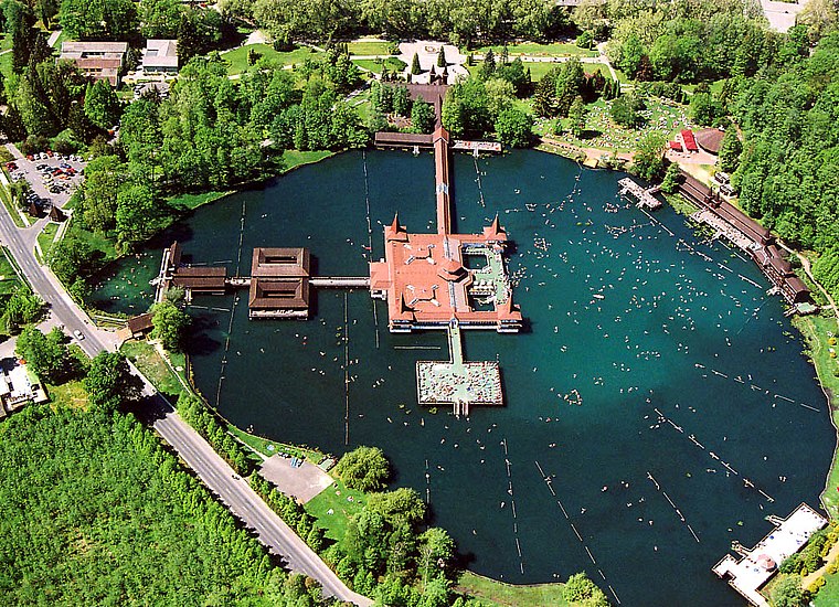
Photo: Wikimedia, CC BY-SA 2.5.
Lake Hévíz is located in Hévíz, Hungary, near the western end of Lake Balaton, 8 kilometres from Keszthely. It is the largest swimmable thermal lake in the world, and is the second largest thermal lake in general, second to only the Frying Pan Lake in New Zealand, which is too hot for swimming.
Mary Magdalene church in Egregy
Church

Photo: Kaboldy, CC BY-SA 3.0.
Mary Magdalene church in Egregy is situated 620 metres north of HeBi - Egregy.
Church of the Holy Spirit Hévíz
Church

Photo: VitVit, CC BY-SA 4.0.
Church of the Holy Spirit Hévíz is situated 1¼ km south of HeBi - Egregy.
Places in the Area
Nearby places include Hévíz and Keszthely.
Hévíz

Photo: HTME, CC BY-SA 3.0.
Hévíz is a spa town in the Lake Balaton region of Hungary, about 8 km from Keszthely.
Keszthely

Photo: AlasdairW, CC BY-SA 3.0.
Keszthely is a Hungarian city of 20,895 inhabitants located on the western shore of Lake Balaton. It is the second largest city by the lake and one of the more important cultural, educational and economic hubs in the region.
Zalaköveskút
Village
 Zalaköveskút is a village in Zala County, Hungary. Zalaköveskút is situated 6 km northwest of HeBi - Egregy.
HeBi - Egregy
- Type: Bike rental
- Category: transportation
- Location: Veszprém County, Central Transdanubia, Hungary, Central Europe, Europe
- View on OpenStreetMap
Latitude
46.8028° or 46° 48′ 10″ northLongitude
17.18855° or 17° 11′ 19″ eastOperator
Hévíz Város ÖnkormányzatNetwork
HeBiOpen location code
8FRVR53Q+4COpenStreetMap ID
node 4573751439OpenStreetMap feature
amenity=bicycle_rental
This page is based on OpenStreetMap, Wikidata, and Wikimedia Commons.
We’d love your help improving our open data sources. Thank you for contributing.
Satellite Map
Discover HeBi - Egregy from above in high-definition satellite imagery.
Notable Places Nearby
Highlights include Jézus Szíve-templom and római villa.
Nearby Places
Explore places such as Hévíz II. ker óvoda (Egregy) and Római katona sírja.
Veszprém County: Must-Visit Destinations
Delve into Veszprém, Pápa, Sümeg, and Várpalota.
Curious Bike Rentals to Discover
Uncover intriguing bike rentals from every corner of the globe.
About Mapcarta. Data © OpenStreetMap contributors and available under the Open Database License". Text is available under the CC BY-SA 4.0 license, except for photos, directions, and the map. Photo: Wikimedia, CC0.