Dorcol /Kneginje Ljubice/
Dorcol /Kneginje Ljubice/ is a tram stop in Opština Beograd-Stari Grad, Belgrade, Central Serbia. Dorcol /Kneginje Ljubice/ is situated nearby to the school First Belgrade Gymnasium, as well as near the university Универзитет Унион - Никола Тесла.| Tap on a place to explore it |
Places of Interest Nearby
Highlights include Science & Technology Museum and Church of Saint Alexander of Neva.
Science & Technology Museum
Museum

Photo: Nanabaka, CC BY-SA 4.0.
Science & Technology Museum is situated 120 metres northeast of Dorcol /Kneginje Ljubice/.
Church of Saint Alexander of Neva
Church

Photo: Andrija12345678, CC BY-SA 4.0.
The Church of St. Alexander Nevsky is a Serbian Orthodox church in Belgrade, Serbia. Church of Saint Alexander of Neva is situated 170 metres southeast of Dorcol /Kneginje Ljubice/.
National Museum of Serbia
Museum
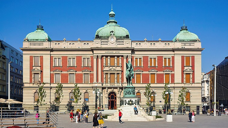
Photo: Simon04, CC BY-SA 4.0.
The National Museum of Serbia is the largest and oldest museum in Belgrade, Serbia. It is located in the central zone of Belgrade on a square plot between the Republic Square, formerly Theatre Square, and three streets: Čika Ljubina, Vasina and Laze Pačua. National Museum of Serbia is situated 590 metres southwest of Dorcol /Kneginje Ljubice/.
Places in the Area
Nearby places include Stari Grad and Dorćol.
Stari Grad
Suburb
 Belgrade is the capital of the Republic of Serbia. It stands at the confluence of the Danube and Sava rivers, where the rolling Pannonian Plain fetches up against the rugged Balkan peninsula, and in 2022 had a population of 1.2 million, about a fifth of Serbia's total.
Dorćol
Neighborhood
Photo: Lumen roma, CC BY 3.0.
Dorćol is an affluent urban neighborhood of Belgrade, the capital of Serbia. It is located in Belgrade's municipality of Stari Grad. Located along the right bank of the Danube, Dorćol is the oldest surviving neighborhood in Belgrade.
Skadarlija
Neighborhood

Photo: Ванилица, CC BY-SA 4.0.
Skadarlija is a vintage street, an urban neighborhood and former municipality of Belgrade, Serbia, located in the Belgrade municipality of Stari Grad. Skadarlija partially preserves the ambience of traditional urban architecture, including archaic urban organization, and is known as the main bohemian quarter of Belgrade, similar to Montmartre in Paris.
Dorcol /Kneginje Ljubice/
- Type: Tram stop
- Categories: bus stop and transportation
- Location: Opština Beograd-Stari Grad, Belgrade, Central Serbia, Serbia, Balkans, Europe
- View on OpenStreetMap
Latitude
44.8211° or 44° 49′ 16″ northLongitude
20.46409° or 20° 27′ 51″ eastOperator
GSP BelgradeNetwork
БГ ПревозOpen location code
8GP2RFC7+CJOpenStreetMap ID
node 4682134316OpenStreetMap feature
highway=bus_stopOpenStreetMap feature
public_transport=platformOpenStreetMap feature
railway=tram_stop
This page is based on OpenStreetMap, Wikidata, and Wikimedia Commons.
We’d love your help improving our open data sources. Thank you for contributing.
Satellite Map
Discover Dorcol /Kneginje Ljubice/ from above in high-definition satellite imagery.
In Other Languages
“Dorcol /Kneginje Ljubice/” goes by many names.
- Serbian: “Dorćol /Kneginje Ljubice/”
- Serbian: “Дорћол /Кнегиње Љубице/”
Notable Places Nearby
Highlights include First Belgrade Gymnasium and Универзитет Унион - Никола Тесла.
Nearby Places
Explore places such as Prva pekara and Dorcol /Kneginje Ljubice/.
Serbia: Must-Visit Destinations
Delve into Novi Sad, Niš, Kragujevac, and Subotica.
Curious Tram Stops to Discover
Uncover intriguing tram stops from every corner of the globe.
About Mapcarta. Data © OpenStreetMap contributors and available under the Open Database License". Text is available under the CC BY-SA 4.0 license, except for photos, directions, and the map. Photo: Wikimedia, CC BY 3.0.