Hôpital Pourtalès
Hôpital Pourtalès is a bus stop in Neuchatel, Canton of Neuchâtel. Hôpital Pourtalès is situated nearby to the post office Bas du Mail, as well as near Réseau hospitalier neuchâtelois - Pourtalès.| Tap on a place to explore it |
Places of Interest Nearby
Highlights include Stade de la Maladière and Basilica of Our Lady of the Assumption, Neuchâtel.
Stade de la Maladière
Stadium
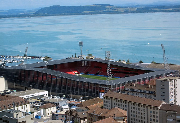 Stade de la Maladière is a multi-purpose stadium in Neuchâtel, Switzerland. It is currently used mostly for football matches and is the home ground of Neuchâtel Xamax. The stadium holds 12,000. It replaced the old Stade de la Maladière. Stade de la Maladière is situated 170 metres east of Hôpital Pourtalès.
Basilica of Our Lady of the Assumption, Neuchâtel
Church

Photo: FOFQ, CC BY-SA 3.0.
The Roman Catholic Our Lady of Assumption Church, also known as the Red Church, stands in the Swiss city of Neuchâtel in the diocese of Lausanne, Geneva and Freiburg. Basilica of Our Lady of the Assumption, Neuchâtel is situated 140 metres southwest of Hôpital Pourtalès.
Neuchâtel Railway Station
Railway station

Photo: Wikimedia, CC BY-SA 3.0.
Neuchâtel railway station serves the municipality of Neuchâtel, the capital city of the canton of Neuchâtel, Switzerland. Opened in 1857, it is owned and operated by SBB-CFF-FFS. Neuchâtel Railway Station is situated 490 metres west of Hôpital Pourtalès.
Places in the Area
Nearby places include Hauterive and Valangin.
Hauterive
Village

Photo: FOFQ, CC BY-SA 3.0.
Hauterive is a former municipality in the canton of Neuchâtel in Switzerland. On 1 January 2025 the former municipalities of Enges, Hauterive, Saint-Blaise and La Tène merged into the new municipality of Laténa. Hauterive is situated 3 km northeast of Hôpital Pourtalès.
Valangin
Village

Photo: Pierre Bona, CC BY-SA 3.0.
Valangin is a former municipality in the district of Val-de-Ruz in the canton of Neuchâtel in Switzerland. On 1 January 2021 the former municipalities of Corcelles-Cormondrèche, Peseux and Valangin merged into the municipality of Neuchâtel. Valangin is situated 3½ km northwest of Hôpital Pourtalès.
Fenin-Vilars-Saules
Village

Photo: Imagepro, CC BY-SA 3.0.
Fenin-Vilars-Saules is a former municipality in the district of Val-de-Ruz in the canton of Neuchâtel in Switzerland. The municipalities of Boudevilliers, Cernier, Chézard-Saint-Martin, Coffrane, Dombresson, Engollon, Fenin-Vilars-Saules, Fontainemelon… Fenin-Vilars-Saules is situated 4 km north of Hôpital Pourtalès.
Hôpital Pourtalès
- Type: Bus stop
- Category: transportation
- Location: Neuchatel, Neuchâtel District, Canton of Neuchâtel, Western Switzerland, Switzerland, Central Europe, Europe
- View on OpenStreetMap
Latitude
46.9958° or 46° 59′ 45″ northLongitude
6.94223° or 6° 56′ 32″ eastElevation
436 metres (1,430 feet)Operator
TRN-tnNetwork
Onde VerteOpen location code
8FR8XWWR+8VOpenStreetMap ID
node 470976857OpenStreetMap feature
highway=bus_stopOpenStreetMap feature
public_transport=platform
This page is based on OpenStreetMap, Wikidata, and Wikimedia Commons.
We’d love your help improving our open data sources. Thank you for contributing.
Satellite Map
Discover Hôpital Pourtalès from above in high-definition satellite imagery.
Notable Places Nearby
Highlights include Bas du Mail and Réseau hospitalier neuchâtelois - Pourtalès.
Nearby Places
Explore places such as Pizza / Kebab Arc-en-Ciel and Maladière.
Western Switzerland: Must-Visit Destinations
Delve into Geneva, Lausanne, Lake Geneva, and Fribourg.
Curious Bus Stops to Discover
Uncover intriguing bus stops from every corner of the globe.
About Mapcarta. Data © OpenStreetMap contributors and available under the Open Database License". Text is available under the CC BY-SA 4.0 license, except for photos, directions, and the map. Photo: Ypsilon from Finland, CC0.