Linha Azul
Linha Azul is a bus stop in São Sebastião, Ponta Delgada. Linha Azul is situated nearby to Hotel Matriz, as well as near the museum Museu Hebraico Sahar Hassamaim.| Tap on a place to explore it |
Places of Interest Nearby
Highlights include Fonte Bela Palace and Portas da Cidade de Ponta Delgada.
Fonte Bela Palace
Castle

Photo: Zeorymer, CC BY-SA 3.0.
Fonte Bela Palace is a castle, which is situated 140 metres west of Linha Azul.
Portas da Cidade de Ponta Delgada
City gate

Photo: Carlos Luis M C da Cruz, Public domain.
Portas da Cidade de Ponta Delgada is a city gate, which is situated 180 metres southeast of Linha Azul.
Ponta Delgada City Hall
Town hall
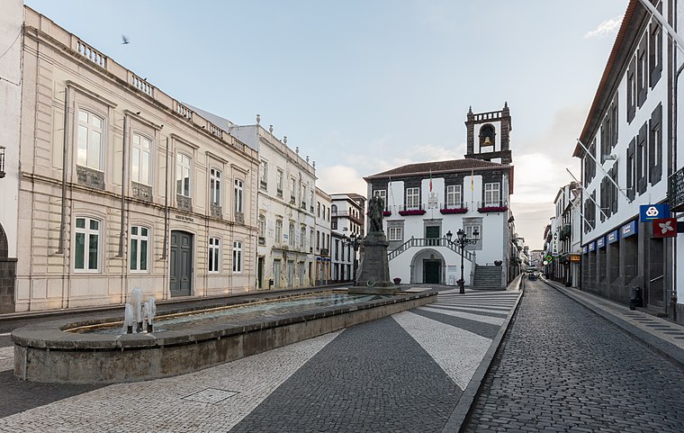
Photo: Wikimedia, CC BY-SA 4.0.
Ponta Delgada City Hall is a 17th-century structure constructed to house the municipal council/authority, situated in the civil parish of São Sebastião, municipality of Ponta Delgada, on the Portuguese archipelago of the Azores. Ponta Delgada City Hall is situated 180 metres south of Linha Azul.
Places in the Area
Nearby places include Fajã de Baixo and Fajã de Cima.
Fajã de Baixo
Village

Photo: Luissilveira, Public domain.
Fajã de Baixo is a civil parish in the municipality of Ponta Delgada in the Portuguese archipelago of the Azores. The population in 2011 was 5,050, in an area of 4.06 km2. Fajã de Baixo is situated 3 km northeast of Linha Azul.
Fajã de Cima
Village

Photo: Luissilveira, Public domain.
Fajã de Cima is a civil parish in the municipality of Ponta Delgada in the Portuguese archipelago of the Azores. Fajã de Cima is located in the Picos region in the western part of the island of São Miguel, north of central Ponta Delgada. Fajã de Cima is situated 3½ km north of Linha Azul.
São Vicente Ferreira
Village
 São Vicente Ferreira is a civil parish in the municipality of Ponta Delgada in the Portuguese archipelago of Azores. The population in 2011 was 2,361, in an area of 11.42 km2. São Vicente Ferreira is situated 9 km north of Linha Azul.
Linha Azul
- Type: Bus stop
- Category: transportation
- Location: São Sebastião, Ponta Delgada, São Miguel, Azores, Portugal, Iberia, Europe
- View on OpenStreetMap
Latitude
37.74063° or 37° 44′ 26″ northLongitude
-25.66994° or 25° 40′ 12″ westOpen location code
899PP8RJ+72OpenStreetMap ID
node 4796851552OpenStreetMap feature
highway=bus_stopOpenStreetMap feature
public_transport=platform
This page is based on OpenStreetMap, Wikidata, and Wikimedia Commons.
We’d love your help improving our open data sources. Thank you for contributing.
Satellite Map
Discover Linha Azul from above in high-definition satellite imagery.
Places with the Same Name
Discover other places named “Linha Azul”.
Notable Places Nearby
Highlights include Hotel Matriz and Museu Hebraico Sahar Hassamaim.
Nearby Places
Explore places such as Montanha and Mango.
Curious Bus Stops to Discover
Uncover intriguing bus stops from every corner of the globe.
About Mapcarta. Data © OpenStreetMap contributors and available under the Open Database License". Text is available under the CC BY-SA 4.0 license, except for photos, directions, and the map. Photo: Apeto, CC BY-SA 3.0.