Bratislavské kultúrne a informačné stredisko
Bratislavské kultúrne a informačné stredisko is a tourism office in Bratislava-Staré Mesto, Bratislava 1, Bratislava Region. Bratislavské kultúrne a informačné stredisko is situated nearby to Museum of Clocks, as well as near the historic building House at the Good Shepherd.| Tap on a place to explore it |
Places of Interest Nearby
Highlights include Bratislava Castle and House at the Good Shepherd.
Bratislava Castle
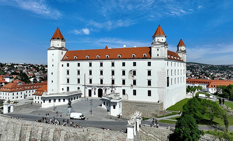
Photo: Bwag, CC BY-SA 4.0.
Bratislava Castle is the main castle of Bratislava, the capital of Slovakia. The massive rectangular building with four corner towers stands on an isolated rocky hill of the Little Carpathians, directly above the Danube river, in the middle of Bratislava. Bratislava Castle is situated 270 metres west of Bratislavské kultúrne a informačné stredisko.
House at the Good Shepherd
Historic building

Photo: Wikimedia, CC BY-SA 4.0.
The House of the Good Shepherd is a narrow, Rococo-style building in Bratislava, Slovakia, located in the Old Town below Bratislava Castle. It was built in 1760–1765 by notable Bratislava master-mason Matej Hollrigl.
Academy of Performing Arts in Bratislava
University

Photo: Wikimedia, Public domain.
The Academy of Performing Arts in Bratislava is a university founded on June 9, 1949. The university consists of three faculties:… Academy of Performing Arts in Bratislava is situated 170 metres east of Bratislavské kultúrne a informačné stredisko.
Places in the Area
Nearby places include Vydrica and Vnútorné mesto.


Podhradie
Neighborhood
Podhradie is a historical part of Bratislava, the capital of Slovakia, situated around the Bratislava Castle hill. Today, it consists of the areas of Zuckermandel, Vydrica and the area above Židovská Street.
Bratislavské kultúrne a informačné stredisko
- Type: Tourism office
- Categories: information and tourism
- Location: Bratislava-Staré Mesto, Bratislava 1, Bratislava Region, Slovakia, Central Europe, Europe
- View on OpenStreetMap
Latitude
48.14202° or 48° 8′ 31″ northLongitude
17.104° or 17° 6′ 14″ eastOpen location code
8FWV44R3+RHOpenStreetMap ID
node 4856551359OpenStreetMap feature
tourism=information
This page is based on OpenStreetMap, Wikidata, and Wikimedia Commons.
We’d love your help improving our open data sources. Thank you for contributing.
Satellite Map
Discover Bratislavské kultúrne a informačné stredisko from above in high-definition satellite imagery.
In Other Languages
“Bratislavské kultúrne a informačné stredisko” goes by many names.
- Hungarian: “Pozsonyi Kulturális és Információs Központ”
Notable Places Nearby
Highlights include Museum of Clocks and Kňazský seminár sv. Cyrila a Metoda.
Nearby Places
Explore places such as Imrich ‘Imi’ Lichtenfeld and Hop Čip Bar.
Slovakia: Must-Visit Destinations
Delve into Bratislava, Košice, Banská Bystrica, and Trnava.
Curious Tourism Offices to Discover
Uncover intriguing tourism offices from every corner of the globe.
About Mapcarta. Data © OpenStreetMap contributors and available under the Open Database License". Text is available under the CC BY-SA 4.0 license, except for photos, directions, and the map. Photo: Danapit, CC BY-SA 3.0.