Gîte Le Chamois
Gîte Le Chamois is a guest house in Chantelouve, Arrondissement of Grenoble, Auvergne-Rhône-Alpes. Gîte Le Chamois is situated nearby to the mountain saddle Col d’Ornon, as well as near the peak Tête des Filons.| Tap on a place to explore it |
Places of Interest Nearby
Highlights include Col d’Ornon and Chapelle Notre-Dame-et-Sainte-Madeleine du Rivier.
Col d’Ornon
Mountain saddle
 Col d'Ornon is a mountain pass through the Dauphiné Alps in the department of Isère in France which connects the communities of Le Bourg-d'Oisans and La Mure.
Chapelle Notre-Dame-et-Sainte-Madeleine du Rivier
Church

Photo: Jjassera, CC BY-SA 3.0.
Chapelle Notre-Dame-et-Sainte-Madeleine du Rivier is a church, which is situated 2½ km north of Gîte Le Chamois.
Grand Glacier
Glacier
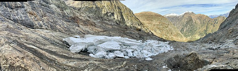
Photo: Aurélienvincent, CC BY-SA 4.0.
Grand Glacier is situated 3 km southwest of Gîte Le Chamois.
Places in the Area
Nearby places include Le Périer.
Le Périer
Quarter

Photo: Eporte, CC BY-SA 3.0.
Le Périer is a former commune in the Isère department in southeastern France. On 1 January 2019, it was merged into the new commune Chantepérier. Le Périer is situated 8 km south of Gîte Le Chamois.
Gîte Le Chamois
- Type: Guest house
- Categories: tourism, accommodation, and building
- Location: Chantelouve, Arrondissement of Grenoble, Isère, Auvergne-Rhône-Alpes, France, Europe
- View on OpenStreetMap
Latitude
45.00789° or 45° 0′ 28″ northLongitude
5.96758° or 5° 58′ 3″ eastOpen location code
8FQ72X59+52OpenStreetMap ID
node 4888006987OpenStreetMap feature
tourism=guest_house
This page is based on OpenStreetMap, Wikidata, and Wikimedia Commons.
We’d love your help improving our open data sources. Thank you for contributing.
Satellite Map
Discover Gîte Le Chamois from above in high-definition satellite imagery.
Notable Places Nearby
Highlights include Col d’Ornon and Source de la Lignarre.
Nearby Places
Explore places such as Le Chamois and Col d’Ornon.
Isère: Must-Visit Destinations
Delve into Grenoble, Vienne, Voiron, and Alpe d’Huez.
Curious Guest Houses to Discover
Uncover intriguing guest houses from every corner of the globe.
About Mapcarta. Data © OpenStreetMap contributors and available under the Open Database License". Text is available under the CC BY-SA 4.0 license, except for photos, directions, and the map. Photo: Samat, CC BY-SA 3.0.