Gazata
Gazata is a clothing store in Indre By, Copenhagen municipality, Capital Region. Gazata is situated nearby to the place of worship House of Unitarians, as well as near the memorial Olaf Rye.| Tap on a place to explore it |
- Opening hours:
Monday—Friday: 11:00 AM—6:00 PM
Saturday: 11:00 AM—3:00 PM
Sunday: closed - Type: Clothing store
- Wheelchair access: no
Places of Interest Nearby
Highlights include House of Unitarians and Parken Stadium.
House of Unitarians
Place of worship

Photo: Wikimedia, Public domain.
"Unitarernes Hus" in Copenhagen, Denmark, is the chapel of the Danish Unitarian Church Society. It was designed by Carl Brummer and opened in 1927 on Østerbrogade.
Parken Stadium
Stadium

Photo: Arne mueseler, CC BY-SA 3.0 de.
Parken, currently known as Parken - Connected by 3 for sponsorship reasons, and as Telia Parken, is a football stadium in the Indre Østerbro district of Copenhagen, Denmark, built from 1990 to 1992. Parken Stadium is situated 1 km northwest of Gazata.
National art museum Copenhagen
Museum
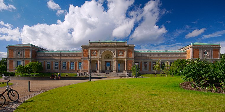
Photo: Jiří Komárek, CC BY-SA 4.0.
The National Gallery of Denmark is the Danish national gallery, located in the centre of Copenhagen. The museum collects, registers, maintains, researches and handles Danish and foreign art dating from the 14th century to the present day. National art museum Copenhagen is situated 790 metres south of Gazata.
Places in the Area
Nearby places include Nyboder and Østerbro.
Nyboder
Quarter

Photo: Wikimedia, CC BY-SA 3.0.
Nyboder is a historic row house district of former Naval barracks in Copenhagen, Denmark. It was planned and first built by Christian IV to accommodate a need for housing for the personnel of the rapidly growing Royal Danish Navy and their families during that time.
Østerbro

Photo: Elgaard, CC BY-SA 3.0.
Østerbro is a mainly residential district of Copenhagen, just north of the inner city. With its quiet cobblestone and tree lined streets, and its excellent shopping and cafe life, it makes for a good excursion from the downtown area.
Indre Østerbro
Neighborhood

Photo: Wikimedia, CC BY-SA 3.0.
Indre Østerbro, was one of the administrative, statistical, and tax city districts comprising the municipality of Copenhagen, Denmark. It lay on the eastern edge of the municipality.
Gazata
- Category: shop
- Location: Indre By, Copenhagen municipality, Capital Region, Denmark, Nordic countries, Europe
- View on OpenStreetMap
Latitude
55.69574° or 55° 41′ 45″ northLongitude
12.58091° or 12° 34′ 51″ eastOpen location code
9F7JMHWJ+79OpenStreetMap ID
node 4933981384OpenStreetMap feature
shop=clothesOpenStreetMap attribute
wheelchair=no
This page is based on OpenStreetMap, Wikidata, and Wikimedia Commons.
We’d love your help improving our open data sources. Thank you for contributing.
Satellite Map
Discover Gazata from above in high-definition satellite imagery.
Places with the Same Name
Discover other places named “Gazata”.
Notable Places Nearby
Highlights include Olaf Rye and Dag Hammarskjölds Alle 28.
Nearby Places
Explore places such as Vino Spiro and Kontra Coffee.
Denmark: Must-Visit Destinations
Delve into Copenhagen, Aarhus, Odense, and Aalborg.
Curious Clothing Stores to Discover
Uncover intriguing clothing stores from every corner of the globe.
About Mapcarta. Data © OpenStreetMap contributors and available under the Open Database License". Text is available under the CC BY-SA 4.0 license, except for photos, directions, and the map. Photo: Wikimedia, CC BY-SA 3.0.