State & Eagle (SE)
State & Eagle (SE) is a bike rental in Albany, Capital District, New York. State & Eagle (SE) is situated nearby to the archaeological site Fort Frederick, as well as near Saint Peter’s Episcopal Church.| Tap on a place to explore it |
Places of Interest Nearby
Highlights include Albany City Hall and MVP Arena.
Albany City Hall
Town hall

Photo: UpstateNYer, CC BY 3.0.
Albany City Hall is the seat of government of the city of Albany, New York, United States. It houses the office of the mayor, the Common Council chamber, the city and traffic courts, as well as other city services. Albany City Hall is situated 360 feet northeast of State & Eagle (SE).
MVP Arena
Stadium
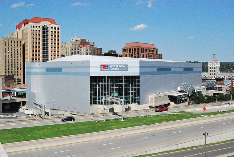
Photo: MattWade, CC BY-SA 3.0.
MVP Arena is an indoor arena located in Albany, New York. It is configurable and can accommodate from 6,000 to 17,500 people, with a maximum seating capacity of 15,500 for sporting events. MVP Arena is situated 920 feet south of State & Eagle (SE).
Fort Frederick
Archaeological site

Photo: UpstateNYer, CC BY-SA 3.0.
Fort Frederick was a fort in Albany, New York from 1676–1789. Sitting atop State Street Hill it replaced the earlier decaying Fort Orange along the Hudson River. Fort Frederick is situated 330 feet southeast of State & Eagle (SE).
Places in the Area
Nearby places include Sheridan Hollow and Arbor Hill Historic District–Ten Broeck Triangle.
Sheridan Hollow
Neighborhood

Photo: Wikimedia, CC BY-SA 2.0.
Sheridan Hollow is a neighborhood in Albany, New York located in a ravine north of Downtown Albany. Capitol Hill to the south and Arbor Hill to the north flank the ravine.
Arbor Hill Historic District–Ten Broeck Triangle
Neighborhood

Photo: UpstateNYer, CC BY-SA 3.0.
The Arbor Hill Historic District–Ten Broeck Triangle, originally the Ten Broeck Historic District, is a seven-block area located within the Arbor Hill neighborhood north of what is today downtown Albany, New York, United States.
Arbor Hill
Neighborhood
Photo: UpstateNYer, CC BY-SA 3.0.
Arbor Hill is a neighborhood in Albany, New York, generally defined as the area from Clinton Avenue north to Tivoli Hollow and the Livingston Avenue Railroad Bridge and from Broadway west to Henry Johnson Boulevard.
State & Eagle (SE)
- Type: Bike rental
- Category: transportation
- Location: Albany, Albany, Capital District, New York, Mid-Atlantic, United States, North America
- View on OpenStreetMap
Latitude
42.65101° or 42° 39′ 4″ northLongitude
-73.75539° or 73° 45′ 19″ westOperator
Social Bicycles Inc.Network
CDPHP CycleOpen location code
87J8M62V+CROpenStreetMap ID
node 5038122392OpenStreetMap feature
amenity=bicycle_rental
This page is based on OpenStreetMap, Wikidata, and Wikimedia Commons.
We’d love your help improving our open data sources. Thank you for contributing.
Satellite Map
Discover State & Eagle (SE) from above in high-definition satellite imagery.
Notable Places Nearby
Highlights include Saint Peter’s Episcopal Church and St. Peter’s Episcopal Church.
Nearby Places
Explore places such as State St & Eagle St and Wellington’s.
Capital District: Must-Visit Destinations
Delve into Troy, Schenectady, Saratoga Springs, and Watervliet.
Curious Bike Rentals to Discover
Uncover intriguing bike rentals from every corner of the globe.
About Mapcarta. Data © OpenStreetMap contributors and available under the Open Database License". Text is available under the CC BY-SA 4.0 license, except for photos, directions, and the map. Photo: UpstateNYer, CC BY-SA 3.0.