2: Mapa de los Ecosistemas
2: Mapa de los Ecosistemas is in Pichincha, Ecuador. 2: Mapa de los Ecosistemas is situated nearby to the public building Instituto Nacional de Biodiversidad, as well as near the garden Jardin Botánico de Quito.| Tap on a place to explore it |
Places of Interest Nearby
Highlights include La Carolina Park and Atahualpa Olympic Stadium.
La Carolina Park
Park

Photo: H3kt0r, CC BY-SA 4.0.
Parque La Carolina is a 165.5-acre park in the centre of the Quito central business district, bordered by the avenues Río Amazonas, de los Shyris, Naciones Unidas, Eloy Alfaro, and de la República. Iñaquito metro station is in the northern part of the park, whereas La Carolina metro station is in the southern part. La Carolina Park is situated 310 metres north of 2: Mapa de los Ecosistemas.
Atahualpa Olympic Stadium
Stadium
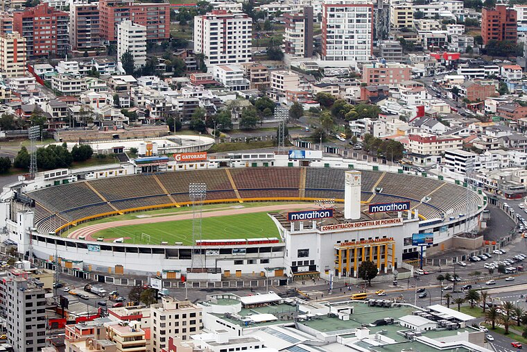
Photo: Agencia de Noticias ANDES, CC BY-SA 2.0.
Atahualpa Olympic Stadium is a multi-purpose stadium in Quito, Ecuador. It is currently used primarily for football matches and has a capacity of 35,258. Atahualpa Olympic Stadium is situated 1¼ km northeast of 2: Mapa de los Ecosistemas.
La Carolina metro station
Metro station

Photo: Freddy eduardo, CC BY-SA 4.0.
La Carolina is a Quito Metro station. It was officially opened on 21 December 2022 as part of the inaugural section of the system between Quitumbe and El Labrador. La Carolina metro station is situated 460 metres south of 2: Mapa de los Ecosistemas.
Places in the Area
Nearby places include Chaupicruz and Quito.
Chaupicruz
Neighborhood
Template:Singles source Chaupicruz is an electoral parish or district of Quito, the capital city of Ecuador in northwestern South America. The parish was established as a result of the October 2004 political elections when the city was divided into 19 urban electoral parishes.
Quito
 Quito, the capital of Ecuador, was founded in 1534 on the ruins of an ancient Inca city. Quito's Old City is the largest in the Americas and was one of the first UNESCO World Heritage Sites, recognized as the largest and most intact colonial city center remaining in the Americas.
2: Mapa de los Ecosistemas
- Type: Sign
- Categories: information and tourism
- Location: Pichincha, Ecuador, South America
- View on OpenStreetMap
Latitude
-0.18627° or 0° 11′ 11″ southLongitude
-78.48517° or 78° 29′ 7″ westOpen location code
67F3RG77+FWOpenStreetMap ID
node 5082161746OpenStreetMap feature
tourism=information
This page is based on OpenStreetMap, Wikidata, and Wikimedia Commons.
We’d love your help improving our open data sources. Thank you for contributing.
Satellite Map
Discover 2: Mapa de los Ecosistemas from above in high-definition satellite imagery.
Notable Places Nearby
Highlights include Instituto Nacional de Biodiversidad and Jardin Botánico de Quito.
Nearby Places
Explore places such as 3: La Palma de Cera and Administración.
Ecuador: Must-Visit Destinations
Delve into Quito, Guayaquil, Chimborazo, and Cuenca.
Curious Places to Discover
Uncover intriguing places from every corner of the globe.
About Mapcarta. Data © OpenStreetMap contributors and available under the Open Database License". Text is available under the CC BY-SA 4.0 license, except for photos, directions, and the map. Photo: Wikimedia, CC0.