Getränke Schröder
Getränke Schröder is a beverage shop in Osnabrück, Western Plains, Lower Saxony which is located on Berghoffstraße. Getränke Schröder is situated nearby to the playground Spielpletz Memeler Straße, as well as near the church St. Barbara.| Tap on a place to explore it |
- Opening hours:
Monday—Friday: 8:00 AM—7:00 PM
Saturday: 8:00 AM—6:00 PM - Type: Beverage shop
- Address: Berghoffstraße 33, Osnabrück, 49090
- Wheelchair access: yes
Places of Interest Nearby
Highlights include St. Barbara and Botanischer Garten der Universität Osnabrück.
St. Barbara
Church

Photo: Ramsch, CC BY-SA 4.0.
St. Barbara is a church, which is situated 270 metres south of Getränke Schröder.
Botanischer Garten der Universität Osnabrück
Garden

Photo: Sail over, CC BY-SA 3.0.
The Botanic Garden of Osnabrück is an institution of Osnabrück University. It is located in the Westerberg area of the city in a former Muschelkalk quarry, Muschelkalk being a shell-bearing limestone of Triassic age typical of Central and Western Europe. Botanischer Garten der Universität Osnabrück is situated 1 km southeast of Getränke Schröder.
Osnabrück Town Hall
Town hall
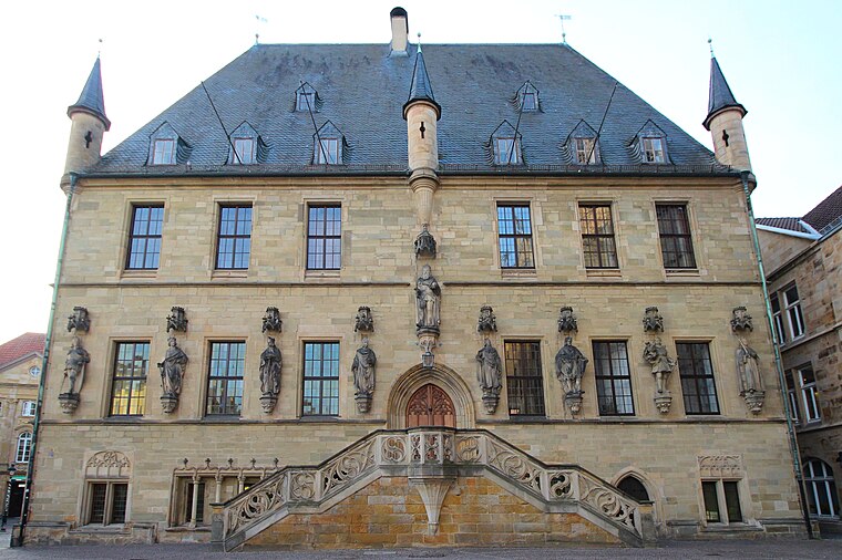
Photo: LigaDue, CC BY-SA 4.0.
The Town Hall of Osnabrück, Germany, was built in the late Gothic style from 1487 to 1512. It is one of Osnabrück's most important buildings and emblems and continues to be used as the city's town hall today. Osnabrück Town Hall is situated 2 km southeast of Getränke Schröder.
Places in the Area
Nearby places include Hafen and Heger-Tor-Viertel.
Hafen
Suburb
Hafen is a district of Osnabrück, Lower Saxony. Germany. It is located in the north-west of the city and had a population of roughly 2,687 residents in 1,454 households as of late 2022.
Heger-Tor-Viertel
Neighborhood

Photo: Timformatiker, CC BY-SA 4.0.
Heger-Tor-Viertel is a neighborhood.
Eversburg
Suburb
Eversburg is a district located in the north-west of the city of Osnabrück, Lower Saxony, Germany.
Getränke Schröder
- Category: shop
- Location: Osnabrück, Western Plains, Lower Saxony, Germany, Central Europe, Europe
- View on OpenStreetMap
Latitude
52.2898° or 52° 17′ 23″ northLongitude
8.02282° or 8° 1′ 22″ eastOpen location code
9F4C72QF+W4OpenStreetMap ID
node 516676154OpenStreetMap feature
shop=beveragesOpenStreetMap attribute
wheelchair=yes
This page is based on OpenStreetMap, Wikidata, and Wikimedia Commons.
We’d love your help improving our open data sources. Thank you for contributing.
Satellite Map
Discover Getränke Schröder from above in high-definition satellite imagery.
Notable Places Nearby
Highlights include Spielpletz Memeler Straße and Nelson-Mandela-Platz.
Nearby Places
Explore places such as Klute Reisen and Schürlkamp.
Western Plains: Must-Visit Destinations
Delve into Oldenburg, Delmenhorst, Nordhorn, and Lingen.
Curious Beverage Shops to Discover
Uncover intriguing beverage shops from every corner of the globe.
About Mapcarta. Data © OpenStreetMap contributors and available under the Open Database License". Text is available under the CC BY-SA 4.0 license, except for photos, directions, and the map. Photo: MrsMyer, CC BY-SA 3.0.