Ordination Für Innere Medizin
Ordination Für Innere Medizin is a doctor’s office in Rudolfsheim-Fünfhaus, Vienna. Ordination Für Innere Medizin is situated nearby to the arts center Der Betrieb, as well as near the tram stop Camillo-Sitte-Gasse.| Tap on a place to explore it |
Places of Interest Nearby
Highlights include Burjanplatz, Vienna and Christkönigskirche, Vienna.
Burjanplatz, Vienna
Park

Photo: Wolfgang glock, CC BY-SA 3.0.
Burjanplatz, Vienna is a park, which is situated 250 metres southeast of Ordination Für Innere Medizin.
Christkönigskirche, Vienna
Church
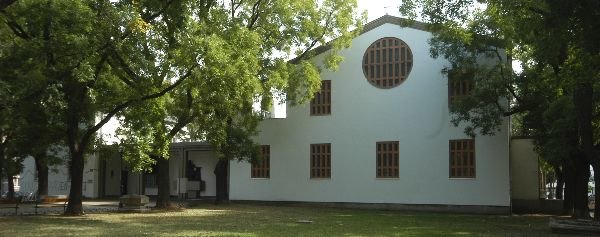
Photo: GuentherZ, CC BY-SA 3.0.
Christkönigskirche, Vienna is a church, which is situated 270 metres southeast of Ordination Für Innere Medizin.
Wien Westbahnhof Railway Station
Railway station
 Wien Westbahnhof is a major Austrian railway station, the original starting point of the West railway and a former terminus of international rail services. Wien Westbahnhof Railway Station is situated 1 km southeast of Ordination Für Innere Medizin.
Places in the Area
Nearby places include Nibelungenviertel and Schmelz.

Schmelz
Neighborhood
Schmelz is a former parade and exercise ground located in Rudolfsheim-Fünfhaus in central Vienna, Austria. It also contained the first football field of SK Rapid Wien between 1899 and 1903.

Ordination Für Innere Medizin
- Type: Doctor’s office
- Wheelchair access: yes
- Category: health care
- Location: Rudolfsheim-Fünfhaus, Vienna, Austria, Central Europe, Europe
- View on OpenStreetMap
Latitude
48.2046° or 48° 12′ 17″ northLongitude
16.32928° or 16° 19′ 45″ eastOpen location code
8FWR683H+RPOpenStreetMap ID
node 5303209301OpenStreetMap feature
amenity=doctorsOpenStreetMap feature
healthcare=doctorOpenStreetMap attribute
wheelchair=yes
This page is based on OpenStreetMap, Wikidata, and Wikimedia Commons.
We’d love your help improving our open data sources. Thank you for contributing.
Satellite Map
Discover Ordination Für Innere Medizin from above in high-definition satellite imagery.
Notable Places Nearby
Highlights include Der Betrieb and Camillo-Sitte-Gasse.
Nearby Places
Explore places such as Elektronik und Technik Markus Widhalm and Dr Harald Winter.
Vienna: Must-Visit Destinations
Delve into Innere Stadt, Vienna International Airport, Inner East, and Alsergrund.
Curious Doctor’s Offices to Discover
Uncover intriguing doctor’s offices from every corner of the globe.
About Mapcarta. Data © OpenStreetMap contributors and available under the Open Database License". Text is available under the CC BY-SA 4.0 license, except for photos, directions, and the map. Photo: Jebulon, CC0.