Hauenreuther Hoflädla
Hauenreuther Hoflädla is a farm shop in Ködnitz, Kulmbach, Bavaria. Hauenreuther Hoflädla is situated nearby to the fire station Freiwillige Feuerwehr Fölschnitz, as well as near the sports venue SKC Fölschnitz 1911 e.V..| Tap on a place to explore it |
Places of Interest Nearby
Highlights include Plassenburg and Rathaus.
Plassenburg
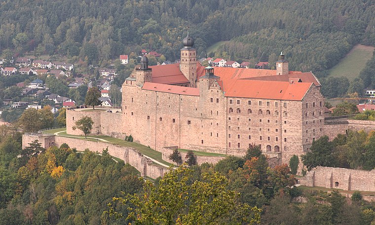
Photo: El Grafo, CC BY-SA 4.0.
Plassenburg is a castle in the city of Kulmbach in Bavaria. It is one of the most impressive castles in Germany and a symbol of the city. It was first mentioned in 1135. Plassenburg is situated 3 km west of Hauenreuther Hoflädla.
Rathaus
Town hall

Photo: Tilman2007, CC BY-SA 3.0.
Rathaus is a town hall, which is situated 3½ km west of Hauenreuther Hoflädla.
Untersteinach
Railway station

Photo: Benreis, CC BY-SA 3.0.
Untersteinach station is a railway station in the municipality of Untersteinach, located in the district of Kulmbach in Middle Franconia, Germany. Untersteinach is situated 3 km northeast of Hauenreuther Hoflädla.
Places in the Area
Nearby places include Untersteinach and Kulmbach.
Untersteinach
Village

Photo: Holy-DYVR, CC BY-SA 4.0.
Untersteinach is a village, which is situated 3 km northeast of Hauenreuther Hoflädla.
Kulmbach

Photo: Ermell, CC BY-SA 4.0.
Kulmbach is a city in Franconia. Its main claim to fame is a high brewery density, which albeit much diminished with economic consolidation was historically quite remarkable.
Ludwigschorgast
Village
 Ludwigschorgast is a municipality in the district of Kulmbach in Upper Franconia in Bavaria, Germany. Ludwigschorgast is situated 4 km northeast of Hauenreuther Hoflädla.
Hauenreuther Hoflädla
- Opening hours: Wednesday noon—6:00 PM and Saturday 9:00 AM—1:00 PM
- Type: Farm shop
- Categories: shop and food
- Location: Ködnitz, Kulmbach, Upper Franconia, Franconia, Bavaria, Germany, Central Europe, Europe
- View on OpenStreetMap
Latitude
50.10787° or 50° 6′ 28″ northLongitude
11.50708° or 11° 30′ 26″ eastOperator
Fam. ZimmermannOpen location code
9F2H4G54+4ROpenStreetMap ID
node 5313176211OpenStreetMap feature
shop=farm
This page is based on OpenStreetMap, Wikidata, and Wikimedia Commons.
We’d love your help improving our open data sources. Thank you for contributing.
Satellite Map
Discover Hauenreuther Hoflädla from above in high-definition satellite imagery.
Notable Places Nearby
Highlights include Freiwillige Feuerwehr Fölschnitz and SKC Fölschnitz 1911 e.V..
Nearby Places
Explore places such as Metzgerei Wehner and Fölschnitz,Ködnitz (Ofr).
Upper Franconia: Must-Visit Destinations
Delve into Bamberg, Bayreuth, Coburg, and Hof.
Curious Farm Shops to Discover
Uncover intriguing farm shops from every corner of the globe.
About Mapcarta. Data © OpenStreetMap contributors and available under the Open Database License". Text is available under the CC BY-SA 4.0 license, except for photos, directions, and the map. Photo: Wikimedia, CC0.