Kriegerdenkmal Mücka
Kriegerdenkmal Mücka is a memorial in Mücka, Görlitz, Saxony. Kriegerdenkmal Mücka is situated nearby to the sports venue Turnhalle, as well as near the manor estate Herrenhaus Mücka.| Tap on a place to explore it |
Places of Interest Nearby
Highlights include Mücka station and Petershain station.
Mücka station
Railway station

Photo: Kleeblatt187, CC BY-SA 4.0.
Mücka/Mikow is a railway station in the village of Mücka, Saxony, Germany. The station lies on the Węgliniec–Roßlau railway, train services are operated by Ostdeutsche Eisenbahn. Mücka station is situated 430 metres northeast of Kriegerdenkmal Mücka.
Petershain station
Railway stop

Photo: Kleeblatt187, CC BY-SA 4.0.
Petershain is a railway station in the village of Quitzdorf am See, Saxony, Germany. The station lies on the Węgliniec–Roßlau railway, train services are operated by Ostdeutsche Eisenbahn. Petershain station is situated 3½ km east of Kriegerdenkmal Mücka.
Gefallenendenkmal Förstgen
Memorial
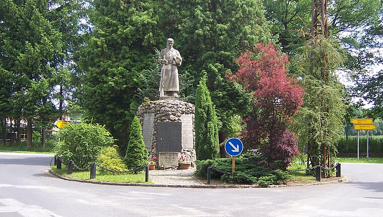
Photo: René Mettke, CC BY-SA 3.0.
Gefallenendenkmal Förstgen is a memorial, which is situated 3½ km southwest of Kriegerdenkmal Mücka.
Places in the Area
Nearby places include Mücka and Horscha.
Mücka
Village

Photo: Wikimedia, CC BY-SA 3.0 de.
Mücka or Mikow is a municipality in the district of Görlitz, Saxony, Germany. The municipality is part of the recognized Sorbian settlement area in Saxony.

Kreba-Neudorf
Village

Photo: J budissin, CC BY 3.0.
Kreba-Neudorf, Upper Sorbian: Chrjebja-Nowa Wjes, is a municipality in the district Görlitz, Saxony, Germany. The municipality is part of the recognized Sorbian settlement area in Saxony. Kreba-Neudorf is situated 3½ km north of Kriegerdenkmal Mücka.
Kriegerdenkmal Mücka
- Type: Memorial
- Inscription: “Denkmal für die Gefallenen des Ersten Weltkrieges”
- Category: historic site
- Location: Mücka, Görlitz, Saxony, Germany, Central Europe, Europe
- View on OpenStreetMap
Latitude
51.31651° or 51° 18′ 59″ northLongitude
14.70171° or 14° 42′ 6″ eastOpen location code
9F3P8P82+JMOpenStreetMap ID
node 5331115231OpenStreetMap feature
historic=memorial
This page is based on OpenStreetMap, Wikidata, and Wikimedia Commons.
We’d love your help improving our open data sources. Thank you for contributing.
Satellite Map
Discover Kriegerdenkmal Mücka from above in high-definition satellite imagery.
Notable Places Nearby
Highlights include Turnhalle and Herrenhaus Mücka.
Nearby Places
Explore places such as Sparkasse Mücka and Red Onion Döner Imbis.
Saxony: Must-Visit Destinations
Delve into Dresden, Leipzig, Chemnitz, and Meißen.
Curious Memorials to Discover
Uncover intriguing memorials from every corner of the globe.
About Mapcarta. Data © OpenStreetMap contributors and available under the Open Database License". Text is available under the CC BY-SA 4.0 license, except for photos, directions, and the map. Photo: Taxiarchos228, FAL.