Armbrustschützenbrunnen
Armbrustschützenbrunnen is a fountain in Nuremberg, Middle Franconia, Bavaria. Armbrustschützenbrunnen is situated nearby to the park Hallerwiese, as well as near Kontumazgarten.| Tap on a place to explore it |
Places of Interest Nearby
Highlights include Kontumazgarten and Nuremberg Castle.

Nuremberg Castle

Photo: ArtMechanic, CC BY-SA 3.0.
Nuremberg Castle is a group of medieval fortified buildings on a sandstone ridge dominating the historical center of Nuremberg in Bavaria, Germany. The castle, together with the city walls, is considered to be one of Europe's most formidable medieval fortifications. Nuremberg Castle is situated 610 metres northeast of Armbrustschützenbrunnen.
Albrecht Dürer’s House
Museum
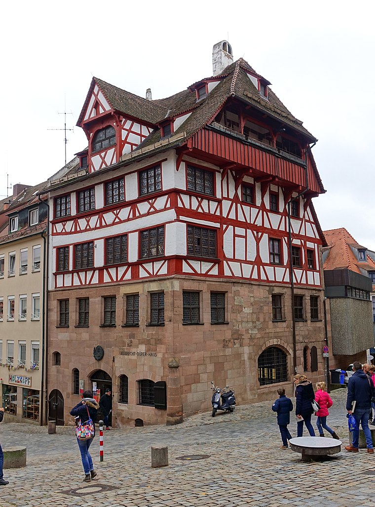 Albrecht Dürer's House is a Nuremberg Fachwerkhaus that was the home of German Renaissance artist Albrecht Dürer from 1509 to his death in 1528. The House lies in the extreme north-west of Nuremberg's Altstadt, near the Kaiserburg section of the Nuremberg Castle and the Tiergärtnertor of Nuremberg's city walls. Albrecht Dürer’s House is situated 460 metres northeast of Armbrustschützenbrunnen.
Places in the Area
Nearby places include Himpfelshof and Lorenz.


Armbrustschützenbrunnen
- Type: Fountain
- Description: water well
- Category: water well
- Location: Nuremberg, Middle Franconia, Franconia, Bavaria, Germany, Central Europe, Europe
- View on OpenStreetMap
Latitude
49.4554° or 49° 27′ 19″ northLongitude
11.06808° or 11° 4′ 5″ eastOpen location code
8FXHF349+56OpenStreetMap ID
node 534726348OpenStreetMap feature
amenity=fountainWikidata ID
Q680489
This page is based on OpenStreetMap, Wikidata, and Wikimedia Commons.
We’d love your help improving our open data sources. Thank you for contributing.
Satellite Map
Discover Armbrustschützenbrunnen from above in high-definition satellite imagery.
In Other Languages
From German to Polish—“Armbrustschützenbrunnen” goes by many names.
- German: “Armbrustschützenbrunnen”
- German: “Schnepperschützenbrunnen”
- Polish: “Armbrustschützenbrunnen”
Notable Places Nearby
Highlights include Hallerwiese and Barockgarten.
Nearby Places
Explore places such as Logenhaus Nürnberg and Parkhaus Hallerwiese.
Middle Franconia: Must-Visit Destinations
Delve into Erlangen, Fürth, Ansbach, and Rothenburg ob der Tauber.
Curious Fountains to Discover
Uncover intriguing fountains from every corner of the globe.
About Mapcarta. Data © OpenStreetMap contributors and available under the Open Database License". Text is available under the CC BY-SA 4.0 license, except for photos, directions, and the map. Photo: Janericloebe, Public domain.