Fatty’s
Fatty’s is a restaurant in Amager Vest, Copenhagen municipality, Capital Region. Fatty’s is situated nearby to the library Islands Brygge Bibliotek, as well as near Hotel Copenhagen.| Tap on a place to explore it |
- Opening hours: 11:30 AM—9:00 PM
- Email: info@fattys.dk
- Type: Restaurant
- Cuisine: burger
- Wheelchair access: limited
Places of Interest Nearby
Highlights include Christiansborg Palace and Tivoli Gardens.
Christiansborg Palace
 Christiansborg Palace is a palace and government building on the islet of Slotsholmen in central Copenhagen, Denmark. It is the seat of the Danish Parliament, the Danish Prime Minister's Office, and the Supreme Court of Denmark. Christiansborg Palace is situated 1 km north of Fatty’s.
Tivoli Gardens
Theme park
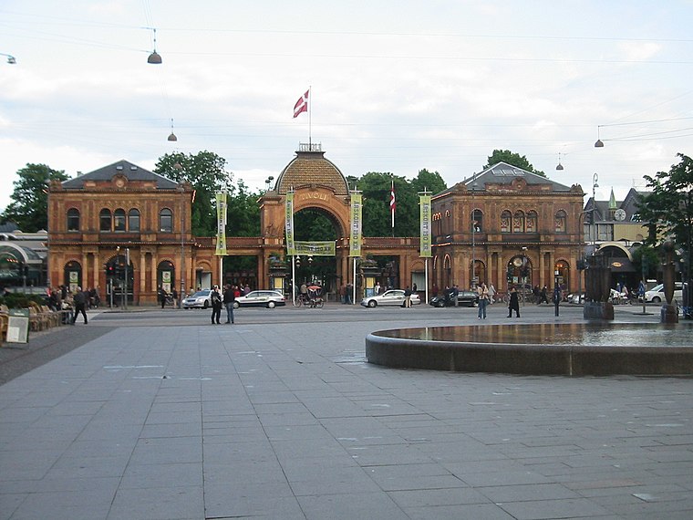
Photo: Elgaard, CC BY-SA 3.0.
Tivoli Gardens, also known simply as Tivoli, is an amusement park and pleasure garden in Copenhagen, Denmark. The park opened on 15 August 1843 and is the second-oldest operating amusement park in the world, after Dyrehavsbakken in nearby Klampenborg, also in Denmark. Tivoli Gardens is situated 1 km northwest of Fatty’s.
Hans Tausen’s Church
Church

Photo: Wikimedia, Public domain.
Hans Tausen's Church is a Church of Denmark parish church in the Islands Brygge neighbourhood of Copenhagen, Denmark. It is named after Hans Tausen, the leading theologian of the Danish Reformation. Hans Tausen’s Church is situated 300 metres southwest of Fatty’s.
Places in the Area
Nearby places include Christianshavn and Postbyen.
Christianshavn

Photo: Elgaard, CC BY-SA 3.0.
Christianshavn is a district east of the inner city of Copenhagen. Once a working-class neighbourhood, today Christianshavn is a trendy part of the city with its own unique identity. people from all walks of life, live side-by-side among cool cafes, old school bodegas, fancy restaurants and charming 19th-century houses along picturesque canals.

Amagerbro
Suburb
Amagerbro is an area in the northern part of the island Amager and a district in Copenhagen. The area is known as a working class area, and has approximately 20,000 inhabitants.
Fatty’s
- Category: food
- Location: Amager Vest, Copenhagen municipality, Capital Region, Denmark, Nordic countries, Europe
- View on OpenStreetMap
Latitude
55.66644° or 55° 39′ 59″ northLongitude
12.58054° or 12° 34′ 50″ eastOpen location code
9F7JMH8J+H6OpenStreetMap ID
node 5418382921OpenStreetMap feature
amenity=restaurantOpenStreetMap attribute
cuisine=burgerOpenStreetMap attribute
wheelchair=limited
This page is based on OpenStreetMap, Wikidata, and Wikimedia Commons.
We’d love your help improving our open data sources. Thank you for contributing.
Satellite Map
Discover Fatty’s from above in high-definition satellite imagery.
Notable Places Nearby
Highlights include Islands Brygge Bibliotek and Hotel Copenhagen.
Nearby Places
Explore places such as Zetland and Pakhus 1.
Denmark: Must-Visit Destinations
Delve into Copenhagen, Aarhus, Odense, and Aalborg.
Curious Restaurants to Discover
Uncover intriguing restaurants from every corner of the globe.
About Mapcarta. Data © OpenStreetMap contributors and available under the Open Database License". Text is available under the CC BY-SA 4.0 license, except for photos, directions, and the map. Photo: Wikimedia, CC BY-SA 3.0.