Floresta Lisbonense
Floresta Lisbonense is a restaurant in São José, Ponta Delgada which is located on R. da Grande Guerra. Floresta Lisbonense is situated nearby to the museum Melo abreu, as well as near the military installation Comando da Zona Marítima dos Açores.| Tap on a place to explore it |
- Opening hours:
Monday—Friday: 10:00 AM—10:00 PM
Saturday—Sunday: closed - Type: Restaurant
- Address: R. da Grande Guerra 20A, Ponta Delgada, 9500-173
Places of Interest Nearby
Highlights include Exemplar de metrosídero (‘Metrosideros excelsa’ Gaertn.), Campo de São Francisco and Church of Nossa Senhora da Esperança.
Exemplar de metrosídero (‘Metrosideros excelsa’ Gaertn.), Campo de São Francisco
Historic site

Photo: Sergey Ashmarin, CC BY-SA 3.0.
Exemplar de metrosídero (‘Metrosideros excelsa’ Gaertn.), Campo de São Francisco is a historic site, which is situated 130 metres west of Floresta Lisbonense.
Church of Nossa Senhora da Esperança
Church

Photo: Wikimedia, CC BY-SA 4.0.
Church of Nossa Senhora da Esperança is situated 160 metres west of Floresta Lisbonense.
Ponta Delgada City Hall
Town hall
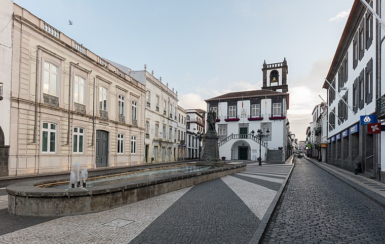
Photo: Wikimedia, CC BY-SA 4.0.
Ponta Delgada City Hall is a 17th-century structure constructed to house the municipal council/authority, situated in the civil parish of São Sebastião, municipality of Ponta Delgada, on the Portuguese archipelago of the Azores. Ponta Delgada City Hall is situated 220 metres northeast of Floresta Lisbonense.
Places in the Area
Nearby places include Fajã de Baixo and Fajã de Cima.
Fajã de Baixo
Village

Photo: Luissilveira, Public domain.
Fajã de Baixo is a civil parish in the municipality of Ponta Delgada in the Portuguese archipelago of the Azores. The population in 2011 was 5,050, in an area of 4.06 km2. Fajã de Baixo is situated 3½ km northeast of Floresta Lisbonense.
Fajã de Cima
Village

Photo: Luissilveira, Public domain.
Fajã de Cima is a civil parish in the municipality of Ponta Delgada in the Portuguese archipelago of the Azores. Fajã de Cima is located in the Picos region in the western part of the island of São Miguel, north of central Ponta Delgada. Fajã de Cima is situated 3½ km north of Floresta Lisbonense.
São Vicente Ferreira
Village
 São Vicente Ferreira is a civil parish in the municipality of Ponta Delgada in the Portuguese archipelago of Azores. The population in 2011 was 2,361, in an area of 11.42 km2. São Vicente Ferreira is situated 9 km north of Floresta Lisbonense.
Floresta Lisbonense
- Category: food
- Location: São José, Ponta Delgada, São Miguel, Azores, Portugal, Iberia, Europe
- View on OpenStreetMap
Latitude
37.73787° or 37° 44′ 16″ northLongitude
-25.67141° or 25° 40′ 17″ westOpen location code
899PP8QH+4COpenStreetMap ID
node 5540394934OpenStreetMap feature
amenity=restaurant
This page is based on OpenStreetMap, Wikidata, and Wikimedia Commons.
We’d love your help improving our open data sources. Thank you for contributing.
Satellite Map
Discover Floresta Lisbonense from above in high-definition satellite imagery.
In Other Languages
“Floresta Lisbonense” goes by many names.
- Portuguese: “Floresta Lisbonense”
Notable Places Nearby
Highlights include Melo abreu and Comando da Zona Marítima dos Açores.
Nearby Places
Explore places such as AMachado Imobiliária - Real Estate Azores and Ilha Verde Rent a Car.
Curious Restaurants to Discover
Uncover intriguing restaurants from every corner of the globe.
About Mapcarta. Data © OpenStreetMap contributors and available under the Open Database License". Text is available under the CC BY-SA 4.0 license, except for photos, directions, and the map. Photo: Apeto, CC BY-SA 3.0.