Slipanlage Hennickendorf
Slipanlage Hennickendorf is a slipway in Rüdersdorf bei Berlin, Märkisch-Oderland, Brandenburg. Slipanlage Hennickendorf is situated nearby to the pitch Hennickendorfer SV 90, as well as near the park Der Lustgarten.| Tap on a place to explore it |
Places of Interest Nearby
Highlights include Wachtelturm and Village church Hennickendorf (Rüdersdorf).
Wachtelturm

Photo: Assenmacher, CC BY-SA 4.0.
Wachtelturm is situated 620 metres northeast of Slipanlage Hennickendorf.
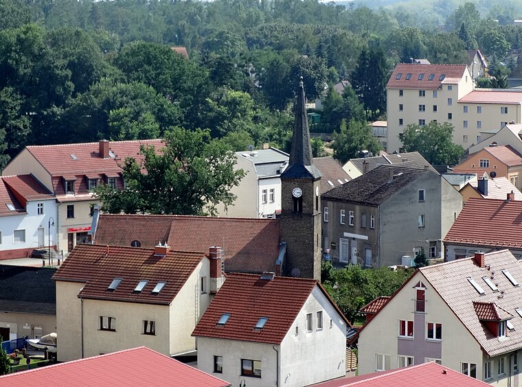
Village church Hennickendorf (Rüdersdorf)
Church

Photo: Assenmacher, CC BY-SA 4.0.
Village church Hennickendorf (Rüdersdorf) is situated 570 metres east of Slipanlage Hennickendorf.

Places in the Area
Nearby places include Hennickendorf and Herzfelde.
Herzfelde
Village

Photo: Marcus Cyron, CC BY-SA 3.0.
Herzfelde is a village, which is situated 3 km south of Slipanlage Hennickendorf.
Eggersdorf
Village

Photo: Molgreen, CC BY-SA 4.0.
Eggersdorf is a village, which is situated 4 km north of Slipanlage Hennickendorf.
Slipanlage Hennickendorf
- Type: Slipway
- Categories: recreation area and transportation
- Location: Rüdersdorf bei Berlin, Märkisch-Oderland, Brandenburg, Germany, Central Europe, Europe
- View on OpenStreetMap
Latitude
52.50638° or 52° 30′ 23″ northLongitude
13.83808° or 13° 50′ 17″ eastOpen location code
9F4MGR4Q+H6OpenStreetMap ID
node 569071072OpenStreetMap feature
leisure=slipway
This page is based on OpenStreetMap, Wikidata, and Wikimedia Commons.
We’d love your help improving our open data sources. Thank you for contributing.
Satellite Map
Discover Slipanlage Hennickendorf from above in high-definition satellite imagery.
Notable Places Nearby
Highlights include Hennickendorfer SV 90 and Der Lustgarten.
Nearby Places
Explore places such as Fischerweg and Anlegestelle Hennickendorf.
Brandenburg: Must-Visit Destinations
Delve into Potsdam, Cottbus, Frankfurt an der Oder, and Brandenburg an der Havel.
Curious Slipways to Discover
Uncover intriguing slipways from every corner of the globe.
About Mapcarta. Data © OpenStreetMap contributors and available under the Open Database License". Text is available under the CC BY-SA 4.0 license, except for photos, directions, and the map. Photo: Leviathan1983, CC BY-SA 3.0.