Ściana straceń
Ściana straceń is a memorial in Gmina Biała Podlaska, Biała County, Lubelskie. Ściana straceń is situated nearby to the tourism office Centrum Informacji Turystycznej, as well as near Post Office.| Tap on a place to explore it |
Places of Interest Nearby
Highlights include St. Anne’s Church, Biała Podlaska and Józef Ignacy Kraszewski Bench in Biała Podlaska.
St. Anne’s Church, Biała Podlaska
Church

Photo: Hiuppo, CC BY-SA 2.5.
St. Anne's Church, in Biała Podlaska, Poland is a Baroque Roman Catholic church. It was originally built in 1572, on the site of an earlier shrine, as a Protestant church dedicated to the Arianism doctrine. St. Anne’s Church, Biała Podlaska is situated 180 metres southwest of Ściana straceń.
Józef Ignacy Kraszewski Bench in Biała Podlaska
Memorial

Photo: Wikimedia, CC BY-SA 4.0.
Józef Ignacy Kraszewski Bench in Biała Podlaska is a memorial.
Saint Anthony church in Biała Podlaska
Church

Photo: Wikimedia, CC BY-SA 4.0.
Saint Anthony church in Biała Podlaska is situated 320 metres southeast of Ściana straceń.
Places in the Area
Nearby places include Biała Podlaska and Sławacinek Stary.
Biała Podlaska
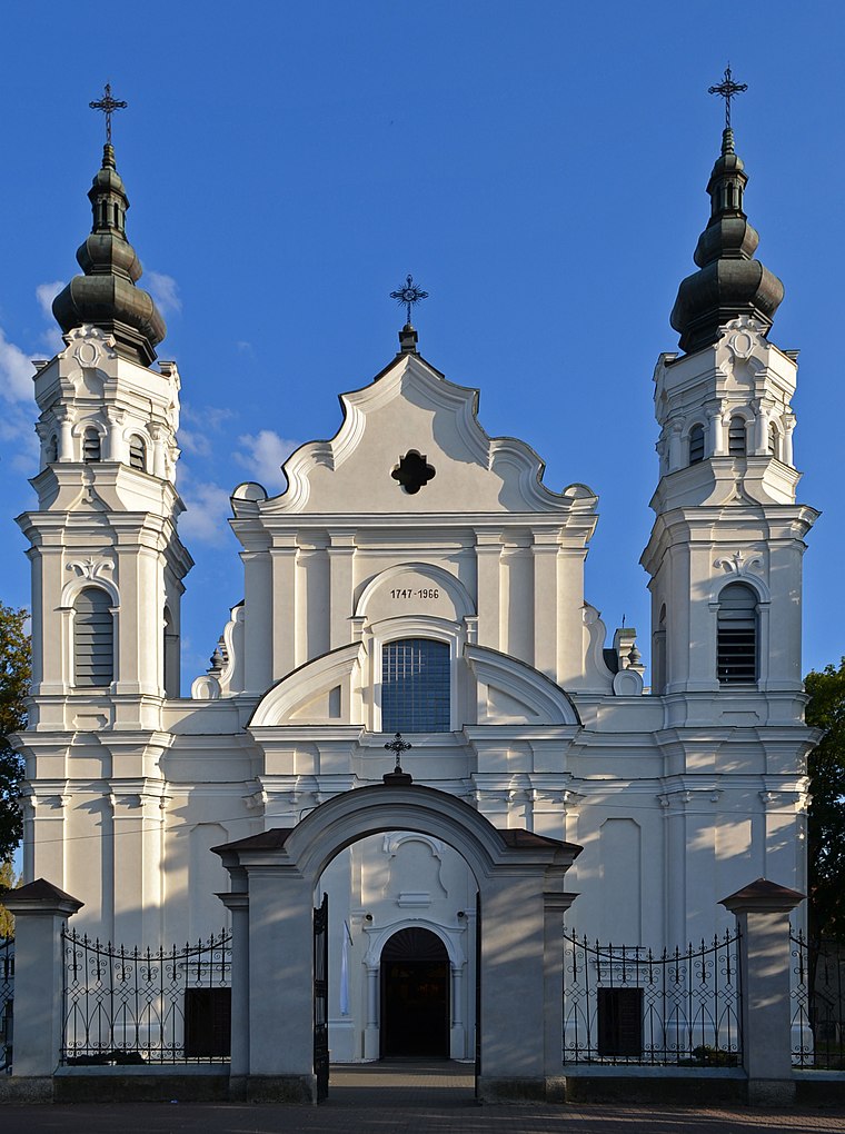
Photo: Wikimedia, CC BY-SA 3.0 pl.
Biała Podlaska is a city in the Lublin Voivodeship in eastern Poland with 56,498 inhabitants as of December 2021. It is the capital of Biała Podlaska County, although the city is not part of the county.
Sławacinek Stary
Village
Sławacinek Stary is a village in the administrative district of Gmina Biała Podlaska, within Biała Podlaska County, Lublin Voivodeship, in eastern Poland. The village's former name was officially used until 1 January 2014. Sławacinek Stary is situated 3½ km west of Ściana straceń.
Rakowiska
Village

Photo: Roch Mściwój, CC BY-SA 4.0.
Rakowiska is a village in the administrative district of Gmina Biała Podlaska, within Biała Podlaska County, Lublin Voivodeship, in eastern Poland. It lies on the border of the city of Biała Podlaska and 98 km north of the regional capital Lublin. Rakowiska is situated 4 km northwest of Ściana straceń.
Ściana straceń
- Type: Memorial
- Category: historic site
- Location: Gmina Biała Podlaska, Biała County, Lubelskie, Poland, Central Europe, Europe
- View on OpenStreetMap
Latitude
52.03436° or 52° 2′ 4″ northLongitude
23.11882° or 23° 7′ 8″ eastOpen location code
9G4524M9+PGOpenStreetMap ID
node 5717167008OpenStreetMap feature
historic=memorial
This page is based on OpenStreetMap, Wikidata, and Wikimedia Commons.
We’d love your help improving our open data sources. Thank you for contributing.
Satellite Map
Discover Ściana straceń from above in high-definition satellite imagery.
Places with the Same Name
Discover other places named “Ściana straceń”.
Notable Places Nearby
Highlights include Centrum Informacji Turystycznej and Post Office.
Nearby Places
Explore places such as Kebab and Warka Pub.
Lubelskie: Must-Visit Destinations
Delve into Lublin, Zamość, Chełm, and Biała Podlaska.
Curious Memorials to Discover
Uncover intriguing memorials from every corner of the globe.
About Mapcarta. Data © OpenStreetMap contributors and available under the Open Database License". Text is available under the CC BY-SA 4.0 license, except for photos, directions, and the map. Photo: Wikimedia, CC0.