Kebab Étretat
Kebab Étretat is a fast food restaurant in Étretat, Arrondissement of Le Havre, Normandy which is located on Avenue de Verdun. Kebab Étretat is situated nearby to the tourism office Office de Tourisme d’Étretat, as well as near the town hall Mairie d’Étretat.| Tap on a place to explore it |
- Type: Fast food restaurant
- Cuisine: kebab
- Address: Avenue de Verdun, Étretat, 76790
Places of Interest Nearby
Highlights include Le Clos Arsène Lupin, Maison Maurice Leblanc and Église Notre-Dame d’Étretat.
Le Clos Arsène Lupin, Maison Maurice Leblanc
Museum
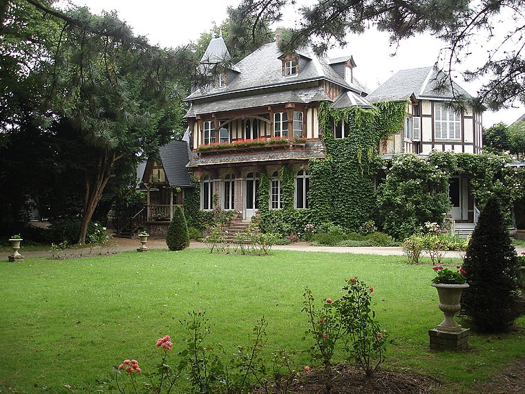
Photo: Wikimedia, CC BY-SA 2.5.
Le Clos Arsène Lupin, Maison Maurice Leblanc is a museum dedicated to the fictional hero Arsène Lupin, created by the writer Maurice Leblanc. The museum is located at 15, rue Guy-de-Maupassant in Étretat, in the former home of Maurice Leblanc. Le Clos Arsène Lupin, Maison Maurice Leblanc is situated 110 metres south of Kebab Étretat.
Église Notre-Dame d’Étretat
Church

Photo: ThruTheseLines, CC BY 2.0.
Église Notre-Dame d’Étretat is a church, which is situated 370 metres east of Kebab Étretat.
Château des Aygues
Castle

Photo: Wikimedia, CC BY-SA 2.5.
Château des Aygues is a castle, which is situated 590 metres southeast of Kebab Étretat.
Places in the Area
Nearby places include Beaurepaire and Anglesqueville-l’Esneval.
Beaurepaire
Village

Photo: touzainphilippe, CC BY 3.0.
Beaurepaire is a commune in the Seine-Maritime department in the Normandy region in northern France. Beaurepaire is situated 4½ km south of Kebab Étretat.
Anglesqueville-l’Esneval
Village

Photo: Havang(nl), CC0.
Anglesqueville-l’Esneval is a commune in the Seine-Maritime department in the Normandy region in northern France. Anglesqueville-l’Esneval is situated 9 km south of Kebab Étretat.
Kebab Étretat
- Categories: food and restaurant
- Location: Étretat, Arrondissement of Le Havre, Seine-Maritime, Normandy, France, Europe
- View on OpenStreetMap
Latitude
49.70725° or 49° 42′ 26″ northLongitude
0.20625° or 0° 12′ 23″ eastOpen location code
8FX2P644+VGOpenStreetMap ID
node 5809106315OpenStreetMap feature
amenity=fast_foodOpenStreetMap attribute
cuisine=kebab
This page is based on OpenStreetMap, Wikidata, and Wikimedia Commons.
We’d love your help improving our open data sources. Thank you for contributing.
Satellite Map
Discover Kebab Étretat from above in high-definition satellite imagery.
Notable Places Nearby
Highlights include Office de Tourisme d’Étretat and Mairie d’Étretat.
Nearby Places
Explore places such as Mairie (Étretat) and Pani Pitt.
Normandy: Must-Visit Destinations
Delve into Orne, Rouen, Seine-Maritime, and Le Havre.
Curious Fast Food Restaurants to Discover
Uncover intriguing fast food restaurants from every corner of the globe.
About Mapcarta. Data © OpenStreetMap contributors and available under the Open Database License". Text is available under the CC BY-SA 4.0 license, except for photos, directions, and the map. Photo: Tim Geers, CC BY-SA 2.0.