鶯
鶯 is a locality in Ogasawara Mura, Ogasawara Subprefecture, Tokyo. 鶯 is situated nearby to the locality Takasagodai, as well as near Chidorigahara.| Tap on a place to explore it |
Places of Interest
Highlights include Iwo Jima and Mount Suribachi.
Iwo Jima
Island
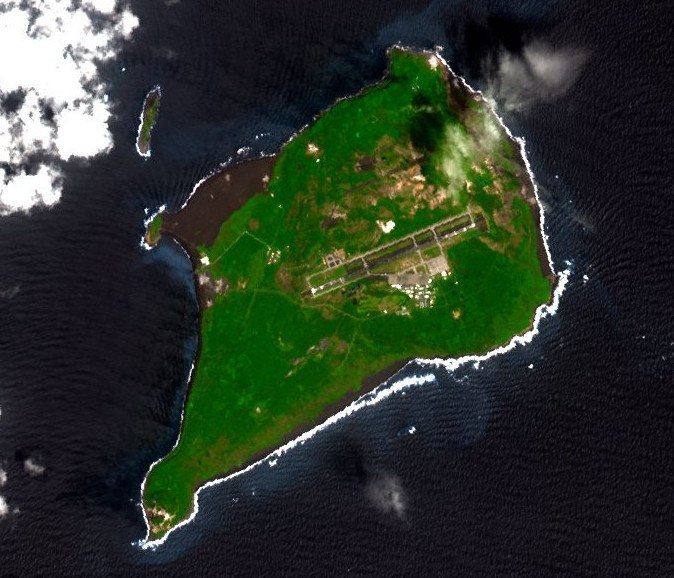
Photo: NASA, Public domain.
Iwo Jima is one of the Japanese Volcano Islands, which lie south of the Bonin Islands and together with them make up the Ogasawara Archipelago. Together with the Izu Islands, they make up Japan's Nanpō Islands.
Mount Suribachi
Peak

Photo: Wikimedia, Public domain.
Mount Suribachi is a 169-metre -high hill on the southwest end of Iwo Jima in the northwest Pacific Ocean under the administration of Ogasawara Subprefecture, Tokyo Metropolis, Japan.
Iwo Jima Air Base
Aerodrome

Photo: Wikimedia, Public domain.
Central Field or Iwo Jima Air Base is a former World War II airfield on Iwo Jima in the Bonin Islands, located in the Central Pacific. The Bonin Islands are part of Japan. Iwo Jima Air Base is situated 3 km northeast of 鶯.
鶯
- Type: Locality
- Location: Ogasawara Mura, Ogasawara Subprefecture, Tokyo, Japan, East Asia, Asia
- View on OpenStreetMap
Latitude
24.77038° or 24° 46′ 13″ northLongitude
141.29926° or 141° 17′ 57″ eastOpen location code
7RP3Q7CX+5POpenStreetMap ID
node 5996386822OpenStreetMap feature
place=locality
This page is based on OpenStreetMap, Wikidata, and Wikimedia Commons.
We’d love your help improving our open data sources. Thank you for contributing.
Satellite Map
Discover 鶯 from above in high-definition satellite imagery.
Localities in the Area
Explore places such as Takasagodai and Chidorigahara.
Notable Places Nearby
Highlights include Chidorigahama and Futatsunehama.
Japan: Must-Visit Destinations
Delve into Tokyo, Osaka, Kyoto, and Yokohama.
Curious Localities to Discover
Uncover intriguing localities from every corner of the globe.
About Mapcarta. Data © OpenStreetMap contributors and available under the Open Database License". Text is available under the CC BY-SA 4.0 license, except for photos, directions, and the map. Photo: JurriaanH, CC BY-SA 3.0.