Primary Care Walk-In Clinic
Primary Care Walk-In Clinic is a clinic in Maricopa County, Arizona which is located on East Palisades Boulevard. Primary Care Walk-In Clinic is situated nearby to Fountain Hills Town Hall, as well as near the police station Maricopa County Sheriff’s Office District 7.| Tap on a place to explore it |
- Opening hours:
Monday—Friday: 9:00 AM—6:00 PM
Saturday: 9:00 AM—3:00 PM - Type: Clinic
- Address: 150, 16605 East Palisades Boulevard, Fountain Hills, AZ 85268
Places of Interest Nearby
Highlights include Fountain Hills High School.
Fountain Hills High School
School
Fountain Hills High School is a public high school in Fountain Hills, Arizona under the jurisdiction of the Fountain Hills Unified School District. Fountain Hills High School was constructed from 1991 to 1993, and its first graduating class was in 1994. Fountain Hills High School is situated 1 mile northwest of Primary Care Walk-In Clinic.
Places in the Area
Nearby places include Fountain Hills and Fort McDowell.
Fountain Hills

Photo: Wikimedia, CC BY-SA 3.0.
Fountain Hills is a town in Maricopa County, Arizona, United States. Known for its impressive fountain, once the tallest in the world, it borders the Fort McDowell Yavapai Nation, Salt River Pima-Maricopa Indian Community, and Scottsdale.
Fort McDowell
Village
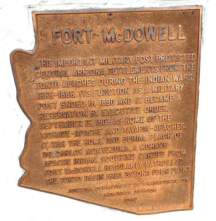
Photo: Marine 69-71, Public domain.
Fort McDowell is an unincorporated community in Maricopa County, Arizona, United States. Fort McDowell is 23 miles northeast of Phoenix. Fort McDowell has a post office with ZIP code 85264. It is part of the Fort McDowell Yavapai Reservation. Fort McDowell is situated 3½ miles northeast of Primary Care Walk-In Clinic.
Primary Care Walk-In Clinic
- Category: health care
- Location: Maricopa County, Arizona, Southwest, United States, North America
- View on OpenStreetMap
Latitude
33.60688° or 33° 36′ 25″ northLongitude
-111.72208° or 111° 43′ 20″ westOpen location code
855CJ74H+Q5OpenStreetMap ID
node 6010725306OpenStreetMap feature
amenity=clinicOpenStreetMap feature
healthcare=clinic
This page is based on OpenStreetMap, Wikidata, and Wikimedia Commons.
We’d love your help improving our open data sources. Thank you for contributing.
Satellite Map
Discover Primary Care Walk-In Clinic from above in high-definition satellite imagery.
Notable Places Nearby
Highlights include Maricopa County Sheriff’s Office District 7 and Fountain Hills Town Hall.
Nearby Places
Explore places such as Fountain Fashions and R & R Nails.
Arizona: Must-Visit Destinations
Delve into Phoenix, Tucson, Mesa, and Flagstaff.
Curious Clinics to Discover
Uncover intriguing clinics from every corner of the globe.
About Mapcarta. Data © OpenStreetMap contributors and available under the Open Database License". Text is available under the CC BY-SA 4.0 license, except for photos, directions, and the map. Photo: Tobi 87, CC BY-SA 3.0.