Rochester LGBTQ Ressources Center
Rochester LGBTQ Ressources Center is a community center in Rochester, Rochester and Suburbs, New York which is located on College Avenue. Rochester LGBTQ Ressources Center is situated nearby to the marketplace Village Gate Square, as well as near University of Rochester Memorial Art Gallery Campus.| Tap on a place to explore it |
Photo: Misc, CC BY-SA 4.0.
- Email: info@outalliance.org
- Type: Community center
- Also known as: “Out Alliance” and “Out Alliance LGBTQ Resource Center”
- Address: 100 College Avenue, Rochester, NY 14607
Places of Interest Nearby
Highlights include Memorial Art Gallery and Main Street Armory.
Memorial Art Gallery
Museum

Photo: DanielPenfield, CC BY-SA 3.0.
The Memorial Art Gallery is a civic art museum in Rochester, New York. Founded in 1913, it is part of the University of Rochester and occupies the southern half of the University's former Prince Street campus. Memorial Art Gallery is situated 800 feet southwest of Rochester LGBTQ Ressources Center.
Main Street Armory
Arts center
 The Main Street Armory is a multi-purpose arena located at 900 East Main Street in Rochester, New York. The Armory was built between 1904 and 1907 by the United States Army and was used for the training and processing of soldiers. Main Street Armory is situated 1,100 feet northwest of Rochester LGBTQ Ressources Center.
George Eastman Museum
Museum

Photo: Dmadeo, CC BY-SA 4.0.
The George Eastman Museum, also referred to as George Eastman House and the International Museum of Photography and Film, is a photography museum, located on the grounds of the George Eastman's estate in Rochester, New York. George Eastman Museum is situated 2,800 feet southeast of Rochester LGBTQ Ressources Center.
Places in the Area
Nearby places include East Avenue Historic District and South Wedge Historic District.
East Avenue Historic District
Neighborhood

Photo: Tim Pierce, CC BY-SA 3.0.
East Avenue Historic District is a national historic district located at Rochester in Monroe County, New York. The district consists of a series of large 19th and early 20th century homes, houses of worship, meeting houses, and museums.
South Wedge Historic District
Neighborhood
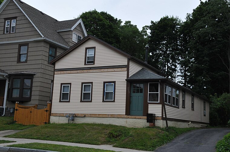
Photo: KLOTZ, CC BY-SA 4.0.
South Wedge is a historic district and neighborhood in southeast Rochester, New York, in a predominantly residential section of the city. The district includes a variety of buildings constructed between the 1840s and 1920s, mainly two-story detached family residences.
Can of Worms
Locality
 The Can of Worms is the local name for the intersection of Interstate 490, I-590, New York State Route 590, NY 96, and University Avenue on the east side of Rochester, New York, in the United States. Can of Worms is situated 2 miles southeast of Rochester LGBTQ Ressources Center.
Rochester LGBTQ Ressources Center
- Categories: LGBT community center and nonprofit organization
- Location: Rochester, Rochester and Suburbs, Finger Lakes, New York, Mid-Atlantic, United States, North America
- View on OpenStreetMap
Latitude
43.1592° or 43° 9′ 33″ northLongitude
-77.58624° or 77° 35′ 11″ westOpen location code
87M45C57+MGOpenStreetMap ID
node 6022243318OpenStreetMap feature
amenity=community_centreWikidata ID
Q63986301
This page is based on OpenStreetMap, Wikidata, and Wikimedia Commons.
We’d love your help improving our open data sources. Thank you for contributing.
Satellite Map
Discover Rochester LGBTQ Ressources Center from above in high-definition satellite imagery.
Notable Places Nearby
Highlights include Village Gate Square and University of Rochester Memorial Art Gallery Campus.
Nearby Places
Explore places such as Rochester Works and The Carnegie Building.
Rochester and Suburbs: Must-Visit Destinations
Delve into Fairport, East Rochester, Victor, and Spencerport.
Curious Community Centers to Discover
Uncover intriguing community centers from every corner of the globe.
About Mapcarta. Data © OpenStreetMap contributors and available under the Open Database License". Text is available under the CC BY-SA 4.0 license, except for photos, directions, and the map. Photo: Misc, CC BY-SA 4.0.