Clínica Walk’in® Telheiras
Clínica Walk’in® Telheiras is a clinic in Lumiar, Lisbon which is located on Azinhaga dos Ulmeiros. Clínica Walk’in® Telheiras is situated nearby to the historic site Bravia Chaimite V-200, as well as near Hospital das Forças Armadas - Pólo de Lisboa.| Tap on a place to explore it |
Places of Interest Nearby
Highlights include Estádio José Alvalade and Estádio da Luz.
Estádio José Alvalade
Stadium
 The Estádio José Alvalade is a football stadium in Lisbon, Portugal, home of Sporting Clube de Portugal. It was built adjacent to the site of the older stadium. Estádio José Alvalade is situated 1¼ km southeast of Clínica Walk’in® Telheiras.
Estádio da Luz
Stadium
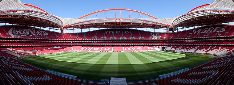
Photo: Massimo Catarinella, CC BY 3.0.
The Estádio da Luz, officially named Estádio do Sport Lisboa e Benfica, is a multi-purpose stadium located in Lisbon, Portugal. It is used mostly for association football matches, hosting the home games of Portuguese club Benfica, its owner. Estádio da Luz is situated 2 km southwest of Clínica Walk’in® Telheiras.
Capela de São Sebastião (Lisboa)
Church

Photo: Vitor Oliveira, CC BY-SA 2.0.
Capela de São Sebastião (Lisboa) is a church, which is situated 480 metres north of Clínica Walk’in® Telheiras.
Places in the Area
Nearby places include Lumiar and Carnide.
Lumiar
Suburb

Photo: João Carvalho, CC BY-SA 3.0.
Lumiar is a freguesia and typical quarter of Lisbon, the capital city of Portugal. Located in northern Lisbon, Lumiar is east of Carnide, north of Alvalade, west of Olivais, and south of Santa Clara and partially of Lisbon's border with Odivelas.
Carnide
Suburb
Carnide is a freguesia and typical quarter of Lisbon, the capital city of Portugal. Located in northern Lisbon, Carnide is north of São Domingos de Benfica and Benfica, east of Lumiar, and directly south of Lisbon's border with Odivelas.
Ameixoeira
Village
Ameixoeira was a Portuguese parish, located in the municipality of Lisbon. It had a population of 9,644 inhabitants and a total area of 1.62 km². With the 2012 Administrative Reform, the parish merged with the Charneca parish into a new one named Santa Clara.
Clínica Walk’in® Telheiras
- Type: Clinic
- Address: Azinhaga dos Ulmeiros, Lisboa, 1600-776
- Categories: hospital and health care
- Location: Lumiar, Lisbon, Lisbon District, Portugal, Iberia, Europe
- View on OpenStreetMap
Latitude
38.76777° or 38° 46′ 4″ northLongitude
-9.17308° or 9° 10′ 23″ westOperator
Walk’in ClinicsOpen location code
8CCGQR9G+4QOpenStreetMap ID
node 6049097592OpenStreetMap feature
amenity=clinicOpenStreetMap feature
healthcare=hospital
This page is based on OpenStreetMap, Wikidata, and Wikimedia Commons.
We’d love your help improving our open data sources. Thank you for contributing.
Satellite Map
Discover Clínica Walk’in® Telheiras from above in high-definition satellite imagery.
Notable Places Nearby
Highlights include Bravia Chaimite V-200 and Hospital das Forças Armadas - Pólo de Lisboa.
Nearby Places
Explore places such as Luxuus Spa Hair and Pingo Doce.
Lisbon: Must-Visit Destinations
Delve into Bairro Alto, Alfama, Baixa, and Belém.
Curious Clinics to Discover
Uncover intriguing clinics from every corner of the globe.
About Mapcarta. Data © OpenStreetMap contributors and available under the Open Database License". Text is available under the CC BY-SA 4.0 license, except for photos, directions, and the map. Photo: Alvesgaspar, CC BY-SA 3.0.