Jamamu Grocery
Jamamu Grocery is a convenience store in Queens, New York. Jamamu Grocery is situated nearby to Evangel Church, as well as near the sports venue Brooklyn Boulders Queensbridge.| Tap on a place to explore it |
Places of Interest Nearby
Highlights include Chase Manhattan Bank Building and Ed Koch Queensboro Bridge.
Chase Manhattan Bank Building
Historic building

Photo: Jim.henderson, CC BY 3.0.
Sven is a residential building located at 29-59 Northern Boulevard in the Long Island City neighborhood of Queens, New York City. At 762 feet tall, Sven is the third-tallest building in Queens behind Skyline Tower and The Orchard, as well as one of the tallest buildings in New York City outside of Manhattan. Chase Manhattan Bank Building is situated 1,400 feet south of Jamamu Grocery.
Ed Koch Queensboro Bridge
Bridge

Photo: Jim.henderson, CC BY-SA 4.0.
The Queensboro Bridge, officially the Ed Koch Queensboro Bridge, is a cantilever bridge over the East River in New York City. Completed in 1909, it connects the Long Island City neighborhood in the borough of Queens with the East Midtown and Upper East Side neighborhoods in Manhattan, passing over Roosevelt Island. Ed Koch Queensboro Bridge is situated 3,700 feet west of Jamamu Grocery.
Queensboro Plaza station
Metro station
 The Queensboro Plaza station is an elevated New York City Subway express station at Queens Plaza in the Long Island City neighborhood of Queens. It is near the east end of the Queensboro Bridge, with Queens Boulevard running east from the plaza. Queensboro Plaza station is situated 1,200 feet southwest of Jamamu Grocery.
Places in the Area
Nearby places include Harold Interlocking and Long Island City and Astoria.
Harold Interlocking
Locality
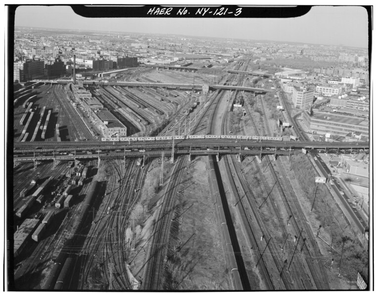
Photo: Jack Boucher, Public domain.
Harold Interlocking is a large railroad junction in New York City. The busiest rail junction in the United States, it serves trains on Amtrak's Northeast Corridor and the Long Island Rail Road's Main Line and Port Washington Branch, which diverge at the junction.
Long Island City and Astoria
 Long Island City is a neighborhood within the New York City borough of Queens. It is bordered by Astoria to the north; the East River to the west; Sunnyside to the east; and Newtown Creek, which separates Queens from Greenpoint, Brooklyn, to the south.
Sunnyside
Neighborhood

Photo: Dialt0ne, Public domain.
Sunnyside is a neighborhood in the western portion of the New York City borough of Queens. It shares borders with Hunters Point and Long Island City to the west, Astoria to the north, Woodside to the east and Maspeth to the south.
Jamamu Grocery
- Type: Convenience store
- Categories: shop and food
- Location: Queens, New York, Mid-Atlantic, United States, North America
- View on OpenStreetMap
Latitude
40.75347° or 40° 45′ 13″ northLongitude
-73.93813° or 73° 56′ 17″ westOpen location code
87G8Q336+9POpenStreetMap ID
node 6064659487OpenStreetMap feature
shop=convenience
This page is based on OpenStreetMap, Wikidata, and Wikimedia Commons.
We’d love your help improving our open data sources. Thank you for contributing.
Satellite Map
Discover Jamamu Grocery from above in high-definition satellite imagery.
Notable Places Nearby
Highlights include Evangel Church and Brooklyn Boulders Queensbridge.
Nearby Places
Explore places such as Citi Bike - 40 Ave & Crescent St and House of Thai.
Queens: Must-Visit Destinations
Delve into John F. Kennedy International Airport, LaGuardia Airport, Flushing-Northeast, and Long Island City and Astoria.
Curious Convenience Stores to Discover
Uncover intriguing convenience stores from every corner of the globe.
About Mapcarta. Data © OpenStreetMap contributors and available under the Open Database License". Text is available under the CC BY-SA 4.0 license, except for photos, directions, and the map. Photo: Wikimedia, CC BY-SA 3.0.