Boundary Monnument 25½
Boundary Monnument 25½ is a geographical marker in Maricopa County, Arizona. Boundary Monnument 25½ is situated nearby to the trailhead Mcdowell Competitive Track, as well as near the peak Lousley Hill.| Tap on a place to explore it |
Places of Interest Nearby
Highlights include Ba Dah Mod Jo Cemetery.
Ba Dah Mod Jo Cemetery
Cemetery

Photo: Marine 69-71, CC BY-SA 4.0.
Ba Dah Mod Jo Cemetery is situated 2 miles south of Boundary Monnument 25½.
Places in the Area
Nearby places include Fort McDowell and Rio Verde.
Fort McDowell
Village
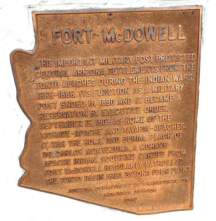
Photo: Marine 69-71, Public domain.
Fort McDowell is an unincorporated community in Maricopa County, Arizona, United States. Fort McDowell is 23 miles northeast of Phoenix. Fort McDowell has a post office with ZIP code 85264. It is part of the Fort McDowell Yavapai Reservation. Fort McDowell is situated 2½ miles southeast of Boundary Monnument 25½.
Rio Verde
Village
Rio Verde is a master-planned community east of Scottsdale in Arizona. It is a census-designated place in Maricopa County, Arizona, United States located in the far northeast area of the Phoenix Metropolitan Area. Rio Verde is situated 4 miles north of Boundary Monnument 25½.
Fountain Hills

Photo: Wikimedia, CC BY-SA 3.0.
Fountain Hills is a town in Maricopa County, Arizona, United States. Known for its impressive fountain, once the tallest in the world, it borders the Fort McDowell Yavapai Nation, Salt River Pima-Maricopa Indian Community, and Scottsdale.
Boundary Monnument 25½
- Type: Geographical marker
- Category: historic site
- Location: Maricopa County, Arizona, Southwest, United States, North America
- View on OpenStreetMap
Latitude
33.67041° or 33° 40′ 14″ northLongitude
-111.69439° or 111° 41′ 40″ westOpen location code
855CM8C4+56OpenStreetMap ID
node 6117121650OpenStreetMap feature
historic=boundary_stone
This page is based on OpenStreetMap, Wikidata, and Wikimedia Commons.
We’d love your help improving our open data sources. Thank you for contributing.
Satellite Map
Discover Boundary Monnument 25½ from above in high-definition satellite imagery.
Notable Places Nearby
Highlights include Mcdowell Competitive Track and Pemberton Trailhead;Maricopa Trail Trailhead.
Nearby Places
Explore places such as Four Peaks Staging Area and Staging Area;Mcdowell Competitive Track.
Arizona: Must-Visit Destinations
Delve into Phoenix, Tucson, Mesa, and Flagstaff.
Curious Geographical Markers to Discover
Uncover intriguing geographical markers from every corner of the globe.
About Mapcarta. Data © OpenStreetMap contributors and available under the Open Database License". Text is available under the CC BY-SA 4.0 license, except for photos, directions, and the map. Photo: Tobi 87, CC BY-SA 3.0.