Paola - Lourdes
Paola - Lourdes is a bus stop in Paola, Malta. Paola - Lourdes is situated nearby to the park Ġnejna l-Ħdax ta‘ Frar, as well as near the garden Ġnien Tony Bezzina.| Tap on a place to explore it |
Places of Interest Nearby
Highlights include Ħal Saflieni Hypogeum and Ħal Tarxien Temples.
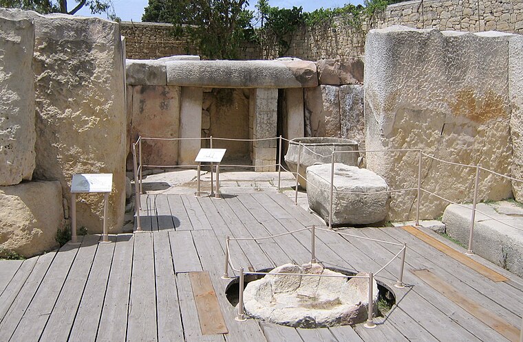
Ħal Saflieni Hypogeum
Museum

Photo: Wikimedia, CC BY-SA 3.0.
The Hypogeum of Ħal Saflieni is a Neolithic subterranean structure dating to the Saflieni phase in Maltese prehistory, located in Paola, Malta. It is often simply referred to as the Hypogeum, literally meaning "underground" in Greek. Ħal Saflieni Hypogeum is situated 730 metres southeast of Paola - Lourdes.
Ħal Tarxien Temples
Protected area
 The Ħal Tarxien Prehistoric Complex is an archaeological complex in Tarxien, within the Port region of Malta. They date to approximately 3400 BC. The site was accepted as a UNESCO World Heritage Site in 1992 along with the other Megalithic temples on the island of Malta. Ħal Tarxien Temples is situated 1 km southeast of Paola - Lourdes.
Mariam Al-Batool Mosque
Mosque

Photo: Wikimedia, CC BY-SA 3.0.
Mariam Al-Batool Mosque is a mosque located in Paola, Malta. The first stone of the mosque was laid by Libyan leader Muammar Gaddafi in 1978 and its doors were open to the public in 1982, and officiated in 1984. Mariam Al-Batool Mosque is situated 500 metres east of Paola - Lourdes.
Places in the Area
Nearby places include Marsa and Malta Dockyard.
Marsa
Village

Photo: Brian Harrington Spier, CC BY-SA 2.0.
Marsa is a town in the Southern Region of Malta, with a population of 4,401 people as of March 2014. The name Marsa means "the harbour".
Malta Dockyard
Locality
Malta Dockyard was an important naval base in the Grand Harbour in Malta in the Mediterranean Sea. The infrastructure which is still in operation is now operated by Palumbo Shipyards.
Tarxien
Village

Photo: Wikimedia, CC BY-SA 3.0.
Tarxien is a town in the Port region of Malta, seat of the Port Regional Council. Its population stood at 8,583 in March 2014. The town is most notable for the Tarxien Temples, a megalithic temple complex which is among the oldest freestanding structures on Earth.
Paola - Lourdes
- Type: Bus stop
- Category: transportation
- Location: Paola, Malta, Europe
- View on OpenStreetMap
Latitude
35.87543° or 35° 52′ 32″ northLongitude
14.50328° or 14° 30′ 12″ eastOperator
Malta Public TransportNetwork
Malta Public TransportOpen location code
8F7PVGG3+58OpenStreetMap ID
node 612085212OpenStreetMap feature
highway=bus_stopOpenStreetMap feature
public_transport=platform
This page is based on OpenStreetMap, Wikidata, and Wikimedia Commons.
We’d love your help improving our open data sources. Thank you for contributing.
Satellite Map
Discover Paola - Lourdes from above in high-definition satellite imagery.
Notable Places Nearby
Highlights include Ġnejna l-Ħdax ta‘ Frar and Ġnien Tony Bezzina.
Nearby Places
Explore places such as Paola - Lourdes and Micro-chip.
Malta: Must-Visit Destinations
Delve into Valletta, Mdina, Sliema, and Victoria.
Curious Bus Stops to Discover
Uncover intriguing bus stops from every corner of the globe.
About Mapcarta. Data © OpenStreetMap contributors and available under the Open Database License". Text is available under the CC BY-SA 4.0 license, except for photos, directions, and the map. Photo: Dirk.heldmaier, CC BY-SA 3.0.