Asociación de Vecinos ‘Barrio de Fígares’
Asociación de Vecinos ‘Barrio de Fígares’ is a government office in Granada, Granada, Andalusia which is located on Calle Marqués de Mondéjar. Asociación de Vecinos ‘Barrio de Fígares’ is situated nearby to the public building Centro Cívico ‘Marqués de Mondéjar’, as well as near the square Plaza de Nuestro Padre Jesús Despojado.| Tap on a place to explore it |
- Opening hours: Monday—Friday 9:00 AM—2:00 PM
- Type: Government office
- Also known as: “AA.VV. Barrio de Fígares”
- Address: Calle Marqués de Mondéjar 3, Granada, 18005
Places of Interest Nearby
Highlights include Alhambra and Alcázar Genil.
Alhambra
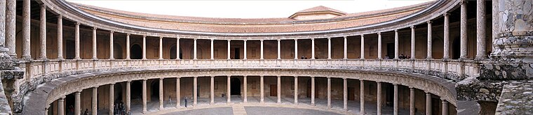
Photo: Bernd Untiedt, CC BY-SA 3.0.
The Alhambra is a palace and fortress complex located in Granada, Spain. It is one of the most famous monuments of Islamic architecture and one of the best-preserved palaces of the historic Islamic world. Alhambra is situated 1¼ km northeast of Asociación de Vecinos ‘Barrio de Fígares’.
Alcázar Genil
Castle

Photo: KronT, Public domain.
The Alcázar Genil is a Muslim-era palace in the city of Granada, Spain. It was originally called al-Qasr al-Sayyid and is located beside the River Genil outside the city walls. Alcázar Genil is situated 390 metres south of Asociación de Vecinos ‘Barrio de Fígares’.
Convento del Ángel Custodio
Church

Photo: AndyVolykhov, CC BY-SA 4.0.
Convento del Ángel Custodio is a church, which is situated 180 metres north of Asociación de Vecinos ‘Barrio de Fígares’.
Places in the Area
Nearby places include Cruz de Lagos and Albaicín.

Albaicín
Quarter

Photo: Miguel303xm, CC BY-SA 2.5.
The Albaicín, also spelled Albayzín, is a neighbourhood of Granada, Spain. It is centered around a hill on the north side of the Darro River which passes through the city.
Sacromonte
Neighborhood
 Sacromonte, sometimes also called Sacramonte, is a traditional neighbourhood in the eastern area of the city of Granada in Andalusia, Spain. It is one of the six neighbourhoods that make up the urban district of Albayzín and borders the neighbourhoods of Albayzín, San Pedro, Realejo-San Matías, El Fargue and Haza Grande.
Asociación de Vecinos ‘Barrio de Fígares’
- Categories: office and government building
- Location: Granada, Granada, Andalusia, Spain, Iberia, Europe
- View on OpenStreetMap
Latitude
37.16827° or 37° 10′ 6″ northLongitude
-3.60039° or 3° 36′ 1″ westOperator
Ayuntamiento de GranadaOpen location code
8C9R599X+8ROpenStreetMap ID
node 6150375727OpenStreetMap feature
office=government
This page is based on OpenStreetMap, Wikidata, and Wikimedia Commons.
We’d love your help improving our open data sources. Thank you for contributing.
Satellite Map
Discover Asociación de Vecinos ‘Barrio de Fígares’ from above in high-definition satellite imagery.
Notable Places Nearby
Highlights include Centro Cívico ‘Marqués de Mondéjar’ and Plaza de Nuestro Padre Jesús Despojado.
Nearby Places
Explore places such as Colegio de Educación Infantil y Primaria Profesor Tierno Galván and Belle Époque.
Granada: Must-Visit Destinations
Delve into Almuñécar, Alhama de Granada, Portugos, and La Alpujarra.
Curious Government Offices to Discover
Uncover intriguing government offices from every corner of the globe.
About Mapcarta. Data © OpenStreetMap contributors and available under the Open Database License". Text is available under the CC BY-SA 4.0 license, except for photos, directions, and the map. Photo: Ogre, Public domain.