Citiz Arras - Place Foch
Citiz Arras - Place Foch is in Arras, Pas-de-Calais, Hauts-de-France. Citiz Arras - Place Foch is situated nearby to the square Place du Maréchal Foch, as well as near the railway station Arras station.| Tap on a place to explore it |
Places of Interest Nearby
Highlights include Arras station and Hôtel de ville.
Arras station
Railway station
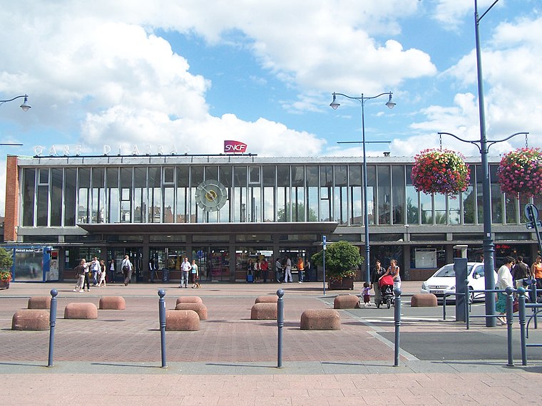
Photo: Floflo, CC BY-SA 3.0.
Arras station is a railway station serving the town Arras, Pas-de-Calais department, northern France. This station, which opened in 1846, is located on the Paris–Lille railway and Arras-Dunkirk railway and accessible from LGV Nord.
Hôtel de ville
Town hall

Photo: Jean-Pol GRANDMONT, CC BY 4.0.
The Hôtel de Ville is a historic building in Arras, Pas-de-Calais, northern France, standing at the northwest end of the Place Des Heros in the centre of the town, and its bell-tower representing the main landmark in the town. Hôtel de ville is situated 540 metres northwest of Citiz Arras - Place Foch.
Belfry of Arras
Scenic viewpoint

Photo: Jean-Pol GRANDMONT, CC BY 4.0.
Belfry of Arras is a scenic viewpoint, which is situated 530 metres northwest of Citiz Arras - Place Foch.
Places in the Area
Nearby places include Monchy-le-Preux.
Monchy-le-Preux
Village

Photo: Pir6mon, CC BY-SA 3.0.
Monchy-le-Preux is a commune in the Pas-de-Calais department in the Hauts-de-France region of France ten kilometres southeast of Arras. Monchy-le-Preux is situated 8 km east of Citiz Arras - Place Foch.
Citiz Arras - Place Foch
- Type: Carsharing
- Category: transportation
- Location: Arras, Arrondissement of Arras, Pas-de-Calais, Hauts-de-France, France, Europe
- View on OpenStreetMap
Latitude
50.28728° or 50° 17′ 14″ northLongitude
2.78147° or 2° 46′ 53″ eastOperator
France AutopartageOpen location code
9F247QPJ+WHOpenStreetMap ID
node 6192081724OpenStreetMap feature
amenity=car_sharing
This page is based on OpenStreetMap, Wikidata, and Wikimedia Commons.
We’d love your help improving our open data sources. Thank you for contributing.
Satellite Map
Discover Citiz Arras - Place Foch from above in high-definition satellite imagery.
Notable Places Nearby
Highlights include Place du Maréchal Foch and Arras.
Nearby Places
Explore places such as Agence commerciale Artis and Arras.
Hauts-de-France: Must-Visit Destinations
Delve into Lille, Dunkirk, Calais, and Amiens.
Curious Places to Discover
Uncover intriguing places from every corner of the globe.
About Mapcarta. Data © OpenStreetMap contributors and available under the Open Database License". Text is available under the CC BY-SA 4.0 license, except for photos, directions, and the map. Photo: Mélanie Huguet, CC BY-SA 3.0.