Kainor
Kainor is a convenience store in São Gonçalo de Lagos, Lagos, Faro District. Kainor is situated nearby to the recreation area Largo da Assembleia Municipal, as well as near the marketplace Mercado Municipal de Santo Amaro.| Tap on a place to explore it |
Places of Interest Nearby
Highlights include Câmara Municipal de Lagos and Lagos Station.
Câmara Municipal de Lagos
Town hall

Photo: Vitor Oliveira, CC BY-SA 2.0.
Câmara Municipal de Lagos is a town hall, which is situated 730 metres east of Kainor.
Lagos Station
Railway station
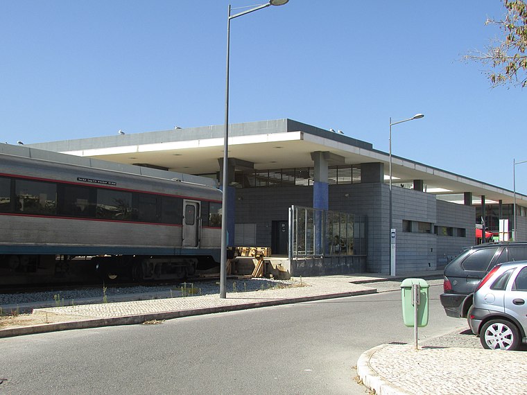
Photo: Creative Commons, CC BY-SA 4.0.
The Lagos railway station is the western terminus of the Algarve line, which serves the city of Lagos, in the Faro District, in Portugal. It opened on the 7th of July 1922. The building was replaced by a new structure in 2003. Lagos Station is situated 1¼ km northeast of Kainor.
Igreja de São Sebastião
Church

Photo: Gomera-b, CC BY-SA 4.0.
Igreja de São Sebastião is a church in Portugal. It is classified as a National Monument. Igreja de São Sebastião is situated 690 metres northeast of Kainor.
Places in the Area
Nearby places include Bairro de Santo Amaro I and Bairro de Casas para Famílias Pobres em Lagos.
Bairro de Santo Amaro I
Neighborhood

Photo: Bextrel, CC BY-SA 4.0.
Bairro de Santo Amaro I is a neighborhood.
Bairro de Casas para Famílias Pobres em Lagos
Neighborhood

Photo: Ajpvalente, CC BY-SA 4.0.
Bairro de Casas para Famílias Pobres em Lagos is a neighborhood.
Praia da Luz
Town
 Praia da Luz, officially Luz, is a civil parish of the municipality of Lagos, in Algarve region, Portugal. The population of the civil parish in 2011 was 3,545, in an area of 21.78 km2. Praia da Luz is situated 4½ km west of Kainor.
Kainor
- Type: Convenience store
- Categories: shop and food
- Location: São Gonçalo de Lagos, Lagos, Faro District, Algarve, Portugal, Iberia, Europe
- View on OpenStreetMap
Latitude
37.10074° or 37° 6′ 3″ northLongitude
-8.68045° or 8° 40′ 50″ westOpen location code
8C9H4829+7ROpenStreetMap ID
node 6198189686OpenStreetMap feature
shop=convenience
This page is based on OpenStreetMap, Wikidata, and Wikimedia Commons.
We’d love your help improving our open data sources. Thank you for contributing.
Satellite Map
Discover Kainor from above in high-definition satellite imagery.
Notable Places Nearby
Highlights include Largo da Assembleia Municipal and Mercado Municipal de Santo Amaro.
Nearby Places
Explore places such as Kohinoor and Rua Hospital São João de Deus - Esc. J. Dantas.
Algarve: Must-Visit Destinations
Delve into Faro, Portimão, Tavira, and Albufeira.
Curious Convenience Stores to Discover
Uncover intriguing convenience stores from every corner of the globe.
About Mapcarta. Data © OpenStreetMap contributors and available under the Open Database License". Text is available under the CC BY-SA 4.0 license, except for photos, directions, and the map. Photo: Jose A., CC BY 2.0.