Manuel’s Fruit & Vegetables
Manuel’s Fruit & Vegetables is a convenience store in Manhattan, New York which is located on 2nd Avenue. Manuel’s Fruit & Vegetables is situated nearby to the church Iglesia Pentecostal Abrigo del Altsimo, as well as near the dōjō Pouncing Tigers.| Tap on a place to explore it |
Places of Interest Nearby
Highlights include Solomon R. Guggenheim Museum and St. Lucy Church.
Solomon R. Guggenheim Museum
Museum
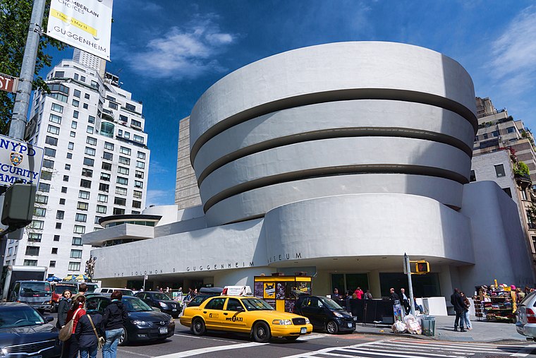
Photo: Jean-Christophe BENOIST, CC BY 3.0.
The Solomon R. Guggenheim Museum, often referred to as The Guggenheim, is an art museum at 1071 Fifth Avenue between 88th and 89th Streets on the Upper East Side of Manhattan in New York City. Solomon R. Guggenheim Museum is situated 1 mile southwest of Manuel’s Fruit & Vegetables.
St. Lucy Church
Church

Photo: Wikimedia, CC BY-SA 3.0.
St. Lucy's Church is a former parish church of the Parish of St. Lucy, which operated under the authority of the Archdiocese of New York in the East Harlem section of the Borough of Manhattan in New York City. St. Lucy Church is situated 700 feet south of Manuel’s Fruit & Vegetables.
Mount Sinai Medical Center
Hospital

Photo: Wikimedia, Public domain.
Mount Sinai Hospital, founded in 1852, is one of the oldest and largest teaching hospitals in the United States. It is located on the Upper East Side of Manhattan in New York City, on the eastern border of Central Park, stretching along Madison and Fifth Avenues, between East 98th Street and East 103rd Street. Mount Sinai Medical Center is situated 2,900 feet west of Manuel’s Fruit & Vegetables.
Places in the Area
Nearby places include East Harlem and Upper East Side.
East Harlem
Neighborhood

Photo: Diensthuber, CC BY 3.0.
East Harlem, also known as Spanish Harlem, or El Barrio, is a neighborhood of Upper Manhattan in New York City, north of the Upper East Side and bounded by 96th Street to the south, Fifth Avenue to the west, and the East and Harlem Rivers to the east and north.
Upper East Side

Photo: Alex Proimos, CC BY 2.0.
The Upper East Side of Manhattan is one of the city's wealthiest districts. Spanning the stretch of island between 59th Street to 96th Street east of Central Park, the neighborhoods of Lenox Hill, Yorkville, and Carnegie Hill are full of luxurious townhouses and apartment buildings on some of the most affluent addresses in New York.
Harlem
Quarter

Photo: Momos, Public domain.
Harlem is a neighborhood in Upper Manhattan, New York City. It is bounded roughly by the Hudson River on the west; the Harlem River and 155th Street on the north; Fifth Avenue on the east; and 110th Street on the south.
Manuel’s Fruit & Vegetables
- Type: Convenience store
- Address: 2060 2nd Avenue, 10029
- Categories: shop and food
- Location: Manhattan, New York, Mid-Atlantic, United States, North America
- View on OpenStreetMap
Latitude
40.79034° or 40° 47′ 25″ northLongitude
-73.94241° or 73° 56′ 33″ westOpen location code
87G8Q3R5+42OpenStreetMap ID
node 6240316488OpenStreetMap feature
shop=convenience
This page is based on OpenStreetMap, Wikidata, and Wikimedia Commons.
We’d love your help improving our open data sources. Thank you for contributing.
Satellite Map
Discover Manuel’s Fruit & Vegetables from above in high-definition satellite imagery.
Notable Places Nearby
Highlights include Iglesia Pentecostal Abrigo del Altsimo and Pouncing Tigers.
Nearby Places
Explore places such as Drug Stop Pharmacy and The Ocky Blend.
Manhattan: Must-Visit Destinations
Delve into Central Park, Upper East Side, Theater District, and Upper West Side.
Curious Convenience Stores to Discover
Uncover intriguing convenience stores from every corner of the globe.
About Mapcarta. Data © OpenStreetMap contributors and available under the Open Database License". Text is available under the CC BY-SA 4.0 license, except for photos, directions, and the map. Photo: Wikimedia, CC BY-SA 3.0.