Sündikat
Sündikat is a shop in Bonn, Cologne District, North Rhine-Westphalia which is located on Friedrichstraße. Sündikat is situated nearby to the art gallery Galerie Bentler, as well as near the tourism office SWB-Servicestelle Bertha-von-Suttner-Platz.| Tap on a place to explore it |
- Opening hours:
Monday—Friday: 11:00 AM—7:00 PM
Saturday: 10:00 AM—6:00 PM - Type: Shop
- Address: Friedrichstraße 53, Bonn, 53111
- Wheelchair access: limited
Places of Interest Nearby
Highlights include Beethoven House and Holy Name Church.
Beethoven House
Museum
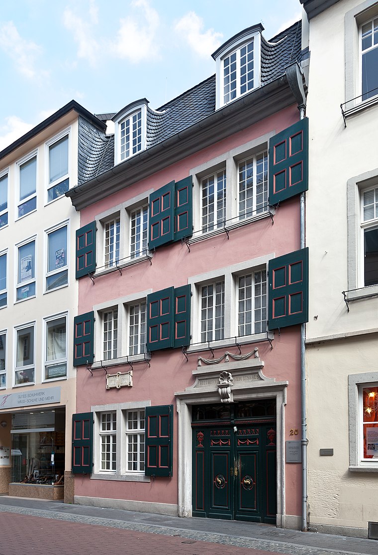
Photo: Der Wolf im Wald, CC BY-SA 3.0 de.
The Beethoven House in Bonn, Germany, is a memorial site, museum, and cultural institution serving various purposes. Founded in 1889 by the Beethoven-Haus association, it studies the life and work of composer Ludwig van Beethoven. Beethoven House is situated 140 metres west of Sündikat.
Holy Name Church
Church

Photo: RomkeHoekstra, CC BY-SA 4.0.
Holy Name Church is situated 150 metres southwest of Sündikat.
St. Remigius
Church

Photo: Filius humanitas, CC BY-SA 3.0.
St. Remigius is a Catholic church and parish in Bonn, Germany. The building was completed in 1307, in Gothic style. St. Remigius is situated 110 metres south of Sündikat.
Places in the Area
Nearby places include Beuel and Poppelsdorf.
Beuel
Suburb

Photo: AKirch-Bonn, CC BY-SA 4.0.
Beuel is a city borough of Bonn, Germany. It has a population of 67,827.
Poppelsdorf
Quarter
Bonn is a federal city in the German state of North Rhine-Westphalia, located on the banks of the Rhine. With a population exceeding 300,000, it lies about 24 km south-southeast of Cologne, in the southernmost part of the Rhine-Ruhr region.
Endenich
Quarter

Photo: Mrhubble, CC BY-SA 3.0.
Endenich is a neighborhood in the western part of Bonn, Germany. Before 1904 it was an independent municipality. The village of Endenich was founded in the 8th century, and was first mentioned in 804 as Antiniche. Today, about 12,000 people live in Endenich.
Sündikat
Latitude
50.73698° or 50° 44′ 13″ northLongitude
7.10329° or 7° 6′ 12″ eastOpen location code
9F29P4P3+Q8OpenStreetMap ID
node 6708135381OpenStreetMap feature
shop=kitchenOpenStreetMap attribute
wheelchair=limited
This page is based on OpenStreetMap, Wikidata, and Wikimedia Commons.
We’d love your help improving our open data sources. Thank you for contributing.
Satellite Map
Discover Sündikat from above in high-definition satellite imagery.
Notable Places Nearby
Highlights include Galerie Bentler and SWB-Servicestelle Bertha-von-Suttner-Platz.
Nearby Places
Explore places such as Heinz Getreider and Paul Getreider.
Cologne Lowland: Must-Visit Destinations
Delve into Cologne, Leverkusen, Siegburg, and Bad Honnef.
Curious Shops to Discover
Uncover intriguing shops from every corner of the globe.
About Mapcarta. Data © OpenStreetMap contributors and available under the Open Database License". Text is available under the CC BY-SA 4.0 license, except for photos, directions, and the map. Photo: Danapit, CC BY-SA 3.0.