Θέα
Θέα is a scenic viewpoint in Mandra-Eidyllia, Attica. Θέα is situated nearby to the church Άγιος Σπυρίδων, as well as near the scenic viewpoint Panoramic View.| Tap on a place to explore it |
Places of Interest Nearby
Highlights include Porto Germeno.
Porto Germeno
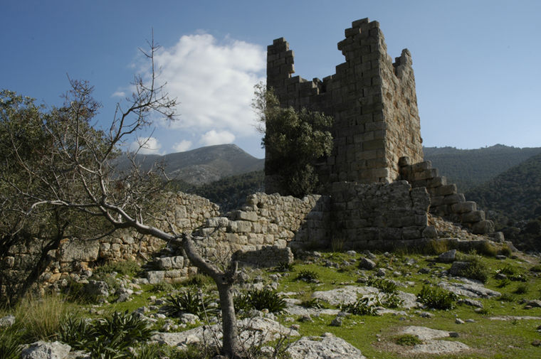
Photo: Nefasdicere, CC BY 2.5.
Aigosthena was an ancient Greek fortified port city of Megaris, 19 km northwest of the ancient city of Megara to which it belonged. It is also the name of the coastal settlement at the foot of the ancient city walls, also known as Porto Germeno. Porto Germeno is situated 1½ km southwest of Θέα.
Places in the Area
Nearby places include Porto Germeno and Plataies.
Porto Germeno
Village

Photo: Nlaskaridis, CC BY-SA 4.0.
Aigosthena was an ancient Greek fortified port city of Megaris, 19 km northwest of the ancient city of Megara to which it belonged. It is also the name of the coastal settlement at the foot of the ancient city walls, also known as Porto Germeno.
Plataies
Village

Photo: Geraki, CC BY-SA 4.0.
Plataies, anciently Kokhla, is a village and a former municipality in Boeotia, Greece. Since the 2011 local government reform it is part of the municipality Thebes, of which it is a municipal unit. Plataies is situated 7 km north of Θέα.
Vilia
Village

Photo: C messier, CC BY-SA 4.0.
Vilia is a village and a former municipality of West Attica, Greece. Since the 2011 local government reform it is part of the municipality Mandra-Eidyllia, of which it is a municipal unit. Vilia is situated 9 km east of Θέα.
Θέα
- Type: Scenic viewpoint
- Category: tourism
- Location: Mandra-Eidyllia, Attica, Greece, Balkans, Europe
- View on OpenStreetMap
Latitude
38.15392° or 38° 9′ 14″ northLongitude
23.24128° or 23° 14′ 29″ eastOpen location code
8GC5563R+HGOpenStreetMap ID
node 6715300749OpenStreetMap feature
tourism=viewpoint
This page is based on OpenStreetMap, Wikidata, and Wikimedia Commons.
We’d love your help improving our open data sources. Thank you for contributing.
Satellite Map
Discover Θέα from above in high-definition satellite imagery.
Places with the Same Name
Discover other places named “Θέα”.
Notable Places Nearby
Highlights include Θέα and Άγιος Σπυρίδων.
Nearby Places
Explore places such as jimny’s corner and Αρτογνωσία.
Greece: Must-Visit Destinations
Delve into Athens, Thessaloniki, Lesvos, and Arcadia.
Curious Scenic Viewpoints to Discover
Uncover intriguing scenic viewpoints from every corner of the globe.
About Mapcarta. Data © OpenStreetMap contributors and available under the Open Database License". Text is available under the CC BY-SA 4.0 license, except for photos, directions, and the map. Photo: Ggia, CC BY-SA 3.0.