Ialoveni Street
Ialoveni Street is a bus stop in Moldova. Ialoveni Street is situated nearby to the church Biserica Baptistă „Golgota”, as well as near the pitch Teren de Fotbal.| Tap on a place to explore it |
Places of Interest Nearby
Highlights include South-West Bus Station and Ștefan cel Mare Academy of the Ministry of Internal Affairs.
South-West Bus Station
Bus station

Photo: Zenwort, CC BY-SA 4.0.
South-West Bus Station is situated 340 metres southwest of Ialoveni Street.
Ștefan cel Mare Academy of the Ministry of Internal Affairs
College
The Ştefan cel Mare Academy of the Ministry of Internal Affairs is the police academy of Moldova. It is named after Stephen III of Moldavia, who ruled the country as Voivode from 1457 and 1504. Ștefan cel Mare Academy of the Ministry of Internal Affairs is situated 700 metres west of Ialoveni Street.
Embassy of Ukraine
Government office
 The Ukrainian Embassy in Chișinău is the diplomatic mission of Ukraine in the Republic of Moldova. The embassy building is located at Vasile Lupu 17 in Chișinău. Ukrainian Ambassador to the Republic of Moldova has been Paun Rohovei since 2025. Embassy of Ukraine is situated 3½ km northeast of Ialoveni Street.
Places in the Area
Nearby places include Codru and Durlești.
Codru
Town

Photo: Ion Chibzii, CC BY-SA 2.0.
Codru formerly known as the Village of Costiujeni, is the second largest suburb of Chișinău city, it is located in the south-west of the Chișinău Municipality. According to the 2014 census the city has over 15000 inhabitants. Codru is situated 4 km southeast of Ialoveni Street.
Durlești
Town

Photo: Tolea93, CC BY-SA 4.0.
Durlești is a town in Chișinău municipality, Moldova. Durlești locality, located in the North-West part of Chisinau, is the largest of the suburbs of the capital. According to the results of the 2024 census, the city proper had a population of 26300. Durlești is situated 4 km northwest of Ialoveni Street.
Sectorul Centru
Suburb
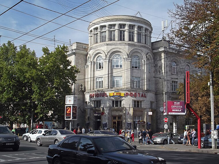
Photo: Борис Мавлютов, CC BY-SA 3.0.
Sectorul Centru is one of the five sectors in Chișinău, the capital of Moldova. The local administration is managed by a pretor appointed by the city administration. Sectorul Centru is situated 4 km northeast of Ialoveni Street.
Ialoveni Street
- Type: Bus stop
- Also known as: “Strada Ialoveni”
- Category: transportation
- Location: Moldova, Balkans, Europe
- View on OpenStreetMap
Latitude
46.99438° or 46° 59′ 40″ northLongitude
28.79367° or 28° 47′ 37″ eastOpen location code
8GRCXQVV+PFOpenStreetMap ID
node 6722212886OpenStreetMap feature
highway=bus_stopOpenStreetMap feature
public_transport=platform
This page is based on OpenStreetMap, Wikidata, and Wikimedia Commons.
We’d love your help improving our open data sources. Thank you for contributing.
Satellite Map
Discover Ialoveni Street from above in high-definition satellite imagery.
In Other Languages
“Ialoveni Street” goes by many names.
- Russian: “ул. Яловенская”
Places with the Same Name
Discover other places named “Ialoveni Street”.
Notable Places Nearby
Highlights include Biserica Baptistă „Golgota” and Teren de Fotbal.
Nearby Places
Explore places such as Strada Ialoveni and Spălătorie Auto.
Moldova: Must-Visit Destinations
Delve into Transnistria, Chișinău, Tiraspol, and Bălţi.
Curious Bus Stops to Discover
Uncover intriguing bus stops from every corner of the globe.
About Mapcarta. Data © OpenStreetMap contributors and available under the Open Database License". Text is available under the CC BY-SA 4.0 license, except for photos, directions, and the map. Photo: USAID Digital Development, CC BY 2.0.