Denkzeichen
Denkzeichen is a work of art in Berlin, Berlin. Denkzeichen is situated nearby to the government office Bundesministerium für Gesundheit, as well as near the theater building Friedrichstadt-Palast.| Tap on a place to explore it |
Places of Interest Nearby
Highlights include Friedrichstadt-Palast and Berlin Wall.
Friedrichstadt-Palast
Theater building

Photo: Arbalete, Public domain.
The Friedrichstadt-Palast, also shortened to Palast Berlin, is a revue theatre in the Berlin district of Mitte. The term Friedrichstadt-Palast refers both to the building as well as the institution and its ensemble.
Berlin Wall

Photo: fauxaddress, CC BY-SA 2.0.
The Berlin Wall, officially the Anti-Fascist Protection Rampart, was a guarded concrete barrier that encircled West Berlin from 1961 to 1989, separating it from East Berlin and the German Democratic Republic. Berlin Wall is situated 1 km north of Denkzeichen.
Pergamon Museum
Museum
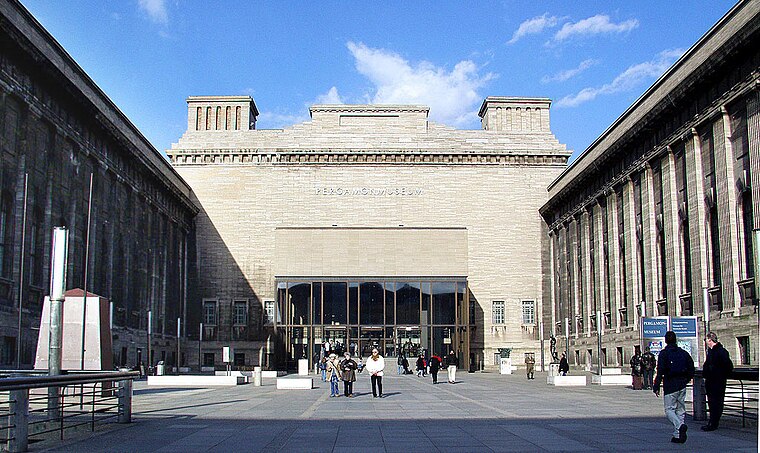
Photo: Wikimedia, CC BY-SA 4.0.
The Pergamon Museum is a listed building on the Museum Island in the historic centre of Berlin, Germany. It was built from 1910 to 1930 by order of Emperor Wilhelm II and according to plans by Alfred Messel and Ludwig Hoffmann in Stripped Classicism style. Pergamon Museum is situated 690 metres southeast of Denkzeichen.
Places in the Area
Nearby places include Dorotheenstadt and Spandauer Vorstadt.
Dorotheenstadt
Quarter
Dorotheenstadt is a historic zone or neighbourhood of central Berlin, Germany, which forms part of the locality of Mitte within the borough also called Mitte.
Spandauer Vorstadt
Quarter
Spandauer Vorstadt is a historic district in what is now the Mitte district of Berlin.
Friedrichswerder
Neighborhood
Friedrichswerder is a neighborhood, situated in the Berliner locality of Mitte, part of the homonymous borough. It is identical to the town of Friedrichswerder, founded in 1662, which was an independent town until 1710.
Denkzeichen
- Type: Work of art
- Artwork type: sculpture
- Category: tourism
- Location: Berlin, Berlin, Stadt, Berlin, Germany, Central Europe, Europe
- View on OpenStreetMap
Latitude
52.52431° or 52° 31′ 28″ northLongitude
13.38792° or 13° 23′ 17″ eastOpen location code
9F4MG9FQ+P5OpenStreetMap ID
node 6736065256OpenStreetMap feature
tourism=artworkOpenStreetMap attribute
artwork_type=sculpture
This page is based on OpenStreetMap, Wikidata, and Wikimedia Commons.
We’d love your help improving our open data sources. Thank you for contributing.
Satellite Map
Discover Denkzeichen from above in high-definition satellite imagery.
Places with the Same Name
Discover other places named “Denkzeichen”.
Notable Places Nearby
Highlights include Bundesministerium für Gesundheit and Bundesministerium für Gesundheit Dienstsitz Berlin.
Nearby Places
Explore places such as Gedenkstele für Max Reinhardt, Hans Poelzig und Erik Charell and Stützpfeiler des früheren Friedrichstadtpalasts.
Berlin: Must-Visit Destinations
Delve into Mitte, East Central, City West, and East Berlin.
Curious Work Of Arts to Discover
Uncover intriguing work of arts from every corner of the globe.
About Mapcarta. Data © OpenStreetMap contributors and available under the Open Database License". Text is available under the CC BY-SA 4.0 license, except for photos, directions, and the map. Photo: Berthold Werner, CC BY-SA 3.0.