U Líbosadu
U Líbosadu is a shelter in Karlovy Vary, Karlovy Vary Region. U Líbosadu is situated nearby to the peak Čertův kámen, as well as near the memorial Kniha.| Tap on a place to explore it |
Places of Interest Nearby
Highlights include Diana Observation Tower and Lesní pobožnost.
Diana Observation Tower
Scenic viewpoint
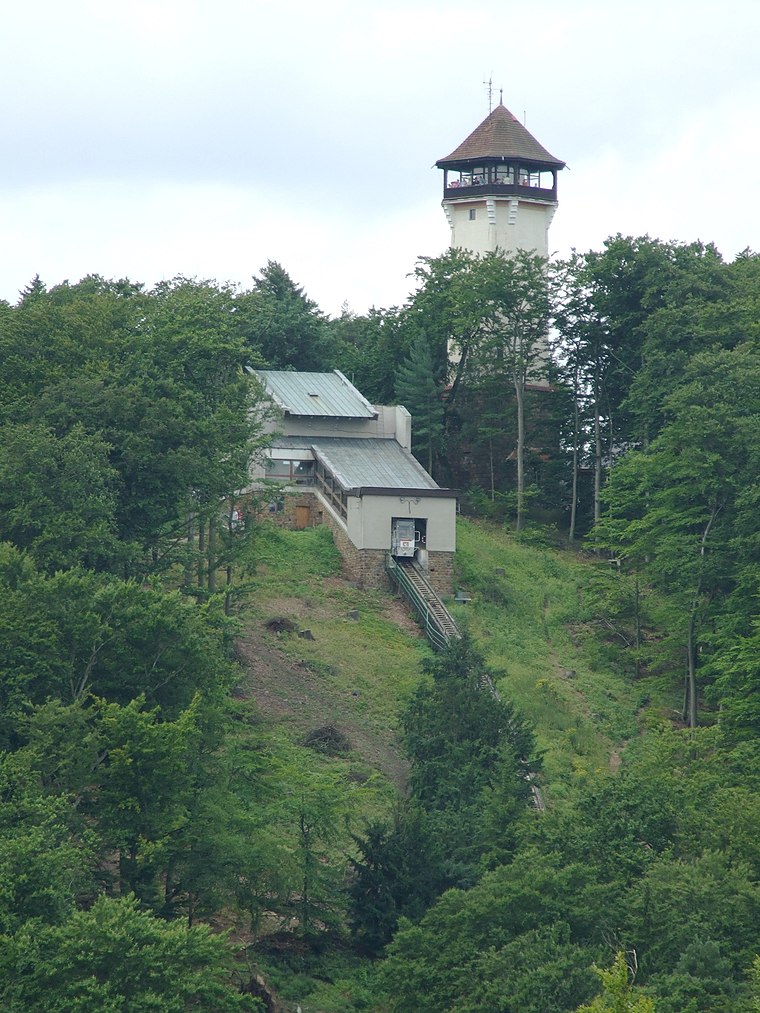
Photo: Wikimedia, CC BY-SA 3.0.
Diana Observation Tower is a scenic viewpoint, which is situated 710 metres east of U Líbosadu.
Lesní pobožnost
Church

Photo: Itsd-foto, CC BY-SA 4.0.
Lesní pobožnost is a church, which is situated 380 metres southeast of U Líbosadu.
Vila Čapek
Public building

Photo: Zorka Sojka, CC BY-SA 4.0.
Vila Čapek is a public building, which is situated 670 metres northeast of U Líbosadu.
Places in the Area
Nearby places include Březová and Bohatice.
Březová
Village
Photo: Packa, CC BY-SA 3.0.
Březová is a municipality and village in Karlovy Vary District in the Karlovy Vary Region of the Czech Republic. It has about 700 inhabitants. Březová is situated 2½ km south of U Líbosadu.
Bohatice
Suburb

Photo: Cheverny, CC BY-SA 4.0.
Bohatice is a suburb, which is situated 2½ km northeast of U Líbosadu.
Sedlec
Suburb

Photo: Lubor Ferenc, CC BY-SA 4.0.
Sedlec is a suburb, which is situated 3 km north of U Líbosadu.
U Líbosadu
Latitude
50.21933° or 50° 13′ 10″ northLongitude
12.86234° or 12° 51′ 44″ eastOpen location code
9F2J6V96+PWOpenStreetMap ID
node 6946423150OpenStreetMap feature
amenity=shelter
This page is based on OpenStreetMap, Wikidata, and Wikimedia Commons.
We’d love your help improving our open data sources. Thank you for contributing.
Satellite Map
Discover U Líbosadu from above in high-definition satellite imagery.
Notable Places Nearby
Highlights include Čertův kámen and Kniha.
Nearby Places
Explore places such as Uhynulý jelen and Párty skončila.
West Bohemia: Must-Visit Destinations
Delve into Pilsen, Cheb, Mariánské Lázně, and Aš.
Curious Shelters to Discover
Uncover intriguing shelters from every corner of the globe.
About Mapcarta. Data © OpenStreetMap contributors and available under the Open Database License". Text is available under the CC BY-SA 4.0 license, except for photos, directions, and the map. Photo: Bobak, CC BY 3.0.