E230-2 Straßenbautechnisches Labor
E230-2 Straßenbautechnisches Labor is an university in Landstraße, Vienna. E230-2 Straßenbautechnisches Labor is situated nearby to the university IMWS Logo Institut für Mechanik der Werkstoffe und Strukturen, as well as near Gebäude OC (ehem. Objekt 236).| Tap on a place to explore it |
Places of Interest Nearby
Highlights include St. Marx Cemetery and Belvedere.
St. Marx Cemetery
Cemetery

Photo: Muehsam, CC BY-SA 3.0.
St. Marx Cemetery is a cemetery in the Landstraße district of Vienna, used from 1784 until 1874. It contains the unmarked grave of the composer Wolfgang Amadeus Mozart. St. Marx Cemetery is situated 320 metres east of E230-2 Straßenbautechnisches Labor.
Belvedere
Park
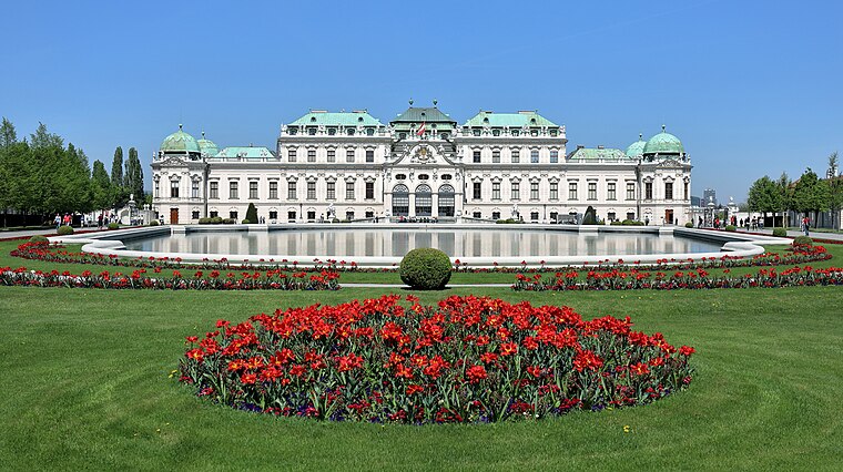
Photo: Bwag, CC BY-SA 4.0.
The Belvedere is a historic building complex in Vienna, Austria consisting of two Baroque palaces, the Orangery, and the Palace Stables. The buildings are set in a Baroque park landscape in the third district of the city, on the south-eastern edge of its centre. Belvedere is situated 2 km northwest of E230-2 Straßenbautechnisches Labor.
Wien Hauptbahnhof
Railway station

Photo: Eweht, CC BY-SA 4.0.
Wien Hauptbahnhof, Vienna Central Station or Vienna Main Station is the main railway station in Vienna, Austria, located in the Favoriten district. It became fully operational in December 2015, linking major railway lines from the north, east, south and west, and replacing the old Wien Südbahnhof terminus. Wien Hauptbahnhof is situated 1½ km west of E230-2 Straßenbautechnisches Labor.
Places in the Area
Nearby places include Vienna Arsenal and Kreta.
Vienna Arsenal
Neighborhood

Photo: Deneb, Public domain.
The Arsenal is a former military complex of buildings in the south-east of Vienna in the third district. Several brick buildings in a rectangle layout make up the complex which is located on a bank south of the Landstraßer Gürtel.


E230-2 Straßenbautechnisches Labor
- Type: University
- Wheelchair access: yes
- Category: education
- Location: Landstraße, Vienna, Austria, Central Europe, Europe
- View on OpenStreetMap
Latitude
48.1818° or 48° 10′ 55″ northLongitude
16.39768° or 16° 23′ 52″ eastOperator
TU WienOpen location code
8FWR59JX+P3OpenStreetMap ID
node 6964890015OpenStreetMap feature
amenity=universityOpenStreetMap attribute
wheelchair=yes
This page is based on OpenStreetMap, Wikidata, and Wikimedia Commons.
We’d love your help improving our open data sources. Thank you for contributing.
Satellite Map
Discover E230-2 Straßenbautechnisches Labor from above in high-definition satellite imagery.
Notable Places Nearby
Highlights include IMWS Logo Institut für Mechanik der Werkstoffe und Strukturen and IFT (E311) - Institut für Fertigungstechnik und Photonische Technologien - TEC-Lab.
Nearby Places
Explore places such as Science Center - Laborgebäude der Fakultät für Bauingenieurwesen and Kühlanlagen.
Vienna: Must-Visit Destinations
Delve into Innere Stadt, Vienna International Airport, Inner East, and Hietzing.
Curious Places to Discover
Uncover intriguing places from every corner of the globe.
About Mapcarta. Data © OpenStreetMap contributors and available under the Open Database License". Text is available under the CC BY-SA 4.0 license, except for photos, directions, and the map. Photo: Miguel Mendez, CC BY 2.0.